
Laives Leifers Trail 2018 - Laives Sky Trail
ITRA
 21.3 km
1560 m
1560 m
21.3 km
1560 m
1560 m

Like
Favorites
Reviews
Share
GPX
4
PDF A4
PDF A0
Profile
Flyover
3D
Insert
Passages
Laives (IT) Inconnu (IT)
Effort kilometer
Longest ascent
Longest descent
36
740 m
1120 m
Max. elevation
Min. elevation
Quality index
1378 m
262 m
 1pt/8m
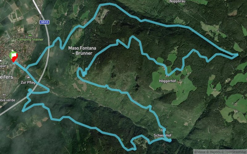
Dopo la partenza dal paese di Laives ad attraversato il centro abitato, si comincia a fare sul serio, imboccando il sentiero n. 1 (sentiero della via crucis).
Passata la settima stazione (mezzavia 5,5 km) si affronta una discesa breve ma tecnica, che porta nelle Vallarsa, da dove si comincia a risalire. A questo punto si percorre l’Alta Via di Laives (panoramica e a tratti tecnica) per poi salire fino al punto più alto del percorso: il maso Högger (1360 mt) e percorrere un bosco meraviglioso che porta al bivio di separazione con il percorso lungo (15,5 km).
Da qui inizia la picchiata verso il paese di Laives attraverso una lunga discesa che metterà alla prova le capacità di ogni atleta.
En voir plus... En voir moins...

Start
Distance
0 km
Altitude
262 m
D+
0 m
D-
0 m
21.3 km
1560 m
1560 m
Finish
Distance
21.3 km
Altitude
262 m
D+
1560 m
D-
1560 m
Click on a point of interest to display it on the map
Reviews and times
Add a track
Laives Leifers Trail 2018 - Laives Sky Trail

Track number : 54295
Link to track :
https://tracedetrail.fr/en/trace/54295
Log in to insert this track on your website
 Trace de Trail