
Ultra Kirklees Way 2018
ITRA
 121.5 km
2440 m
2450 m
121.5 km
2440 m
2450 m

Like
Favorites
Reviews
Share
GPX
4
PDF A4
PDF A0
Profile
Flyover
3D
Insert
Passages
Lindley Ward (GB) Inconnu (GB)
Effort kilometer
Longest ascent
Longest descent
145
200 m
270 m
Max. elevation
Min. elevation
Quality index
454 m
32 m
 1pt/29m
A very much, back to basics, ultra marathon.
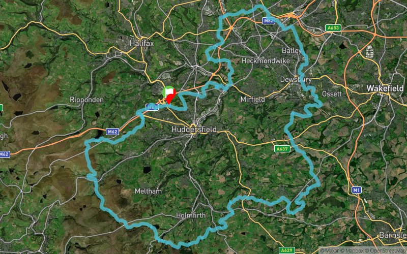
None stop, self sufficient, ultra marathon with 118 km - 73 miles over 4000 ft of accent
The anti clockwise route visits the upper Colne Valley, Spen Valley and Holme Valley and passes Dewsbury, Holmfirth and Marsden. Highlights on the route include a series of picturesque reservoirs including Holme Styes, Ramsden, Digley and Bilberry Reservoirs.
Most of the route is way marked but you will require basic navigation skills (some of this, you will be doing at night... we will NOT assist! The required maps and route descriptions are available for down load. (we did complete the whole recce without maps, but we also know the area!)
Cut off time (21 hours) will be in force NO exceptions, if you can't make the cut off don't enter.
En voir plus... En voir moins...

Start
Distance
0 km
Altitude
181 m
D+
0 m
D-
0 m
121.5 km
2440 m
2450 m
Finish
Distance
121.5 km
Altitude
181 m
D+
2440 m
D-
2450 m
Click on a point of interest to display it on the map
Reviews and times
Add a track
Ultra Kirklees Way 2018

Track number : 50411
Link to track :
https://tracedetrail.fr/en/trace/50411
Log in to insert this track on your website
 Trace de Trail