
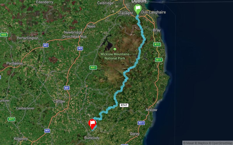
Wicklow Way Race 2018
ITRA
 130.7 km
4050 m
4080 m
130.7 km
4050 m
4080 m

Like
Favorites
Reviews
Share
GPX
28
PDF A4
PDF A0
Profile
Flyover
3D
Insert
Passages
Dublin 14 (IE) Inconnu (IE)
Effort kilometer
Longest ascent
Longest descent
171
450 m
450 m
Max. elevation
Min. elevation
Quality index
631 m
45 m
 1pt/17m
A race over the Wicklow Way from Marlay Park to Clonegal with a maximum allowed time of 21 hours. The race will start at the plaque marking the start of the Wicklow Way in Marlay Park. It is anticipated that registration will be from 22:00 to 23:30 with the race starting at midnight. Runners must follow the Wicklow Way route as it is on the day of the race. This means that any diversions signposted on the day must be followed.
En voir plus... En voir moins...

Start
Distance
0 km
Altitude
85 m
D+
0 m
D-
0 m
130.7 km
4050 m
4080 m
Finish
Distance
130.7 km
Altitude
57 m
D+
4050 m
D-
4080 m
Click on a point of interest to display it on the map
Reviews and times
Add a track
Wicklow Way Race 2018

Track number : 48338
Link to track :
https://tracedetrail.fr/en/trace/48338
Log in to insert this track on your website
 Trace de Trail