
Glendalough Clover 2018
ITRA
 79.8 km
2740 m
2740 m
79.8 km
2740 m
2740 m

Like
Favorites
Reviews
Share
GPX
7
PDF A4
PDF A0
Profile
Flyover
3D
Insert
Passages
Wicklow (IE) Inconnu (IE)
Effort kilometer
Longest ascent
Longest descent
107
480 m
460 m
Max. elevation
Min. elevation
Quality index
579 m
134 m
 1pt/12m
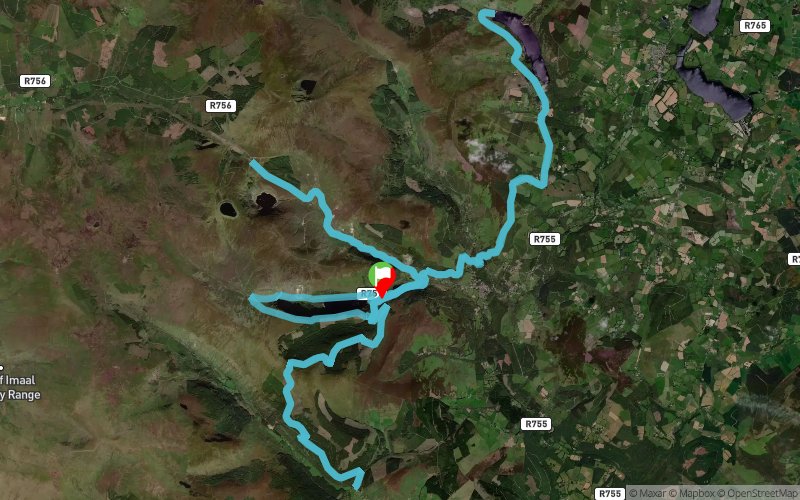
The Glendalough Clover is an 80km ultra distance mountain run based on three ‘out & back’ loops. The race takes place in the Glendalough Valley and will be run along the way-marked trails of St Kevin’s Way, the Spink and The Wicklow Way. The course will be fully marked by use of St Kevin’s Way signage and Wicklow Way signage. Some additional markings may be added at the organiser’s discretion, but the way mark posts of the existing trails are considered sufficient for navigation. The route consists of three separate legs and will be run as a continuous single-stage, free-pace, semi-self-sufficiency race that must be completed within a set time. The total route is approximately 80km in distance, with a total climb in the region of 3,000m. The race route must be run in the set direction and format as announced on the day of the race. The start and finish area will be situated beside the Upper Lake Car-park in the Glendalough Valley.
The start/finish area will also play host to a feed station and drop bag zone (to be known as “Central Base”) that will be visited by each competitor at the end of leg 1, again at the end of leg 2, and finally the finish line at the end of leg 3. Three further water stations will be located at each turn-around point on the route, i.e. at the Wicklow Gap, at Lough Dan, and at Glenmalure.
En voir plus... En voir moins...

Start
Distance
0 km
Altitude
140 m
D+
0 m
D-
0 m
79.8 km
2740 m
2740 m
Finish
Distance
79.8 km
Altitude
140 m
D+
2740 m
D-
2740 m
Click on a point of interest to display it on the map
Reviews and times
Add a track
Glendalough Clover 2018

Track number : 48332
Link to track :
https://tracedetrail.fr/en/trace/48332
Log in to insert this track on your website
 Trace de Trail