
Fruška Gora 2018 - Ultra Extreme Trail Marathon
ITRA
 133.7 km
5700 m
5700 m
133.7 km
5700 m
5700 m


Like
Favorites
Reviews
Share
GPX
10
PDF A4
PDF A0
Profile
Flyover
3D
Insert
Passages
Inconnu (RS) Inconnu (RS)
Effort kilometer
Longest ascent
Longest descent
190
380 m
420 m
Max. elevation
Min. elevation
Quality index
532 m
148 m
 1pt/12m
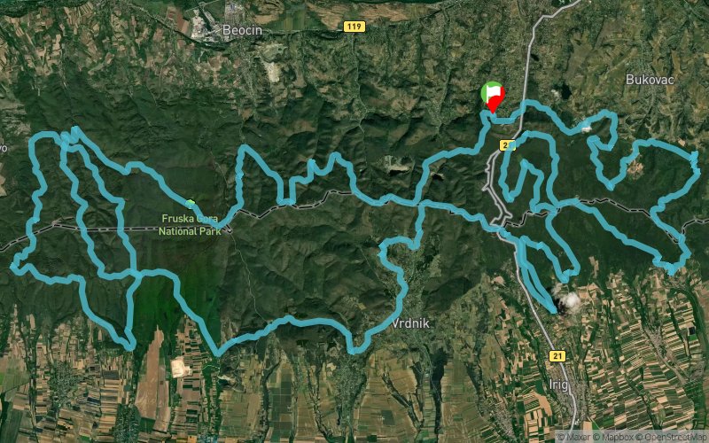
Staza Ultra ekstremnog maratona je najteža, ali ujedno i najlepša kružna staza koju vam mi nudimo. Proteže se kroz najživopisnije predele Nacionalnog parka ''Fruška gora''.
Tokom trke, ima?ete priliku da osetite sve izazove koji donosi trail tr?anje (tehni?ki zahtevne delove staze po kamenitoj i zemljanoj podlozi, gustu šumu, kretanje u no?nim i otežanim uslovim).
Start i Cilj maratona je na Popovici (omiljeno izletište gra?ana Novog Sada). Duž staze, ima?ete priliku da vidite i pro?ete kroz brojne srednjovekovne srpske manastire: Grgeteg (XV vek), Staro Hopovo (XVI vek), Novo Hopovo (XIV vek), Jazak (XVI vek), Bešenovo (VIII vek). Vide?ete betonsku gra?evinu televizijskog releja razrušenu u NATO bombardovanju 1999. godine (tzv. TV toranj), Etno naselje ''Vrdni?ku kulu'', pregazite brojne potoke, popnete se na najviši vrh Fruške gore (539 m) i silazite niz slap Dumbova?kog potoka.
Staza ne izgleda teško, ali verujte nam da sa pravom nosi naziv Ultra ekstremni maraton.
En voir plus... En voir moins...

Start
Distance
0 km
Altitude
305 m
D+
0 m
D-
0 m
133.7 km
5700 m
5700 m
Finish
Distance
133.7 km
Altitude
305 m
D+
5700 m
D-
5700 m
Click on a point of interest to display it on the map
Reviews and times
Add a track
Fruška Gora 2018 - Ultra Extreme Trail Marathon

Track number : 47377
Link to track :
https://tracedetrail.fr/en/trace/47377
Log in to insert this track on your website
 Trace de Trail