
La Corsa della Bora 2018 - S1 Ipertrail 167 km
ITRA
 165.2 km
6640 m
6640 m
165.2 km
6640 m
6640 m

Like
Favorites
Reviews
Share
GPX
83
PDF A4
PDF A0
Profile
Flyover
3D
Insert
Passages
Sistiana (IT) Inconnu (ND)
Effort kilometer
Longest ascent
Longest descent
231
540 m
680 m
Max. elevation
Min. elevation
Quality index
1064 m
-6 m
 1pt/15m
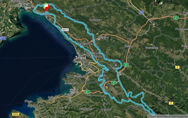
A perfect ring, starting by the sea, first along the Gulf of Trieste, then to enter the highlands of the Bora wind, to reach the snowy Mount Slavnik, running on the border ridge between Italy and Slovenia, between Slovenia and Croatia and coming back to Italy on the CAI 3, who became famous for the “Cavalcata Carsica”.
“The wildest and most Resilient Endurance Run”
logo-s1-iper_90 A continuous alteration of fast sections, breathtaking views of the Gulf of Trieste and steep paths in the magical and wild beech forests of Slovenia. A trail that embodies all the variety of landscapes and terrain, from the dry limestone and Dolomite to the snowy peaks of Slovenia. Sections where navigation takes place following the ridges and with GPS along with wild slopes which then lead to easy tracks. Each section is a surprise, every kilometer a challenge in adaptation.
The route will be marked in the main points, the marked trails with hiking signs, but the use of GPS is required. If there is snow, strong winds or adverse conditions may be the only way not to get lost.
En voir plus... En voir moins...

Sistiana
Distance
0 km
Altitude
53 m
D+
0 m
D-
0 m
165.2 km
6640 m
6640 m
Finish
Distance
165.2 km
Altitude
53 m
D+
6640 m
D-
6640 m
Click on a point of interest to display it on the map
Reviews and times
Add a track
La Corsa della Bora 2018 - S1 Ipertrail 167 km

Track number : 45050
Link to track :
https://tracedetrail.fr/en/trace/45050
Log in to insert this track on your website
 Trace de Trail