
Ultra-Trail® Drakensberg 2018 - UTD 100
ITRA
 99.3 km
4340 m
4560 m
99.3 km
4340 m
4560 m

Like
Favorites
Reviews
Share
GPX
20
PDF A4
PDF A0
Profile
Flyover
3D
Insert
Passages
Inconnu (ND) Inconnu (ND)
Effort kilometer
Longest ascent
Longest descent
142
1030 m
1290 m
Max. elevation
Min. elevation
Quality index
2875 m
1540 m
 1pt/12m
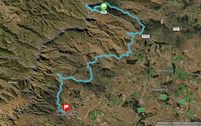
Ultra-Trail® Drakensberg (UTD) is 100km in length with 4400m of vertical climb and occupies an altitude window between 1600m and 2865m.
The Race Start is at the South African Border Post on the Sani Pass rd at 05h00 on Saturday morning. The first 13km of the race is on the dirt road of Sani Pass which allows the field to spread out before the athletes enter 87km of unbroken mountain trail. The climb to the summit of the Sani Pass includes just over 1000m of vertical climb in the first 8km and the runners top out on the escarpment with the sunrise at 2865m. They then plunge back down the Sani Pass and into the trail which traverses the Twelve Apostles for 6km before the long and fast 19km descent down the Khanti Ridge to Sani Pass Hotel.
From the Hotel the course climbs the beautiful Gxalingenwa Gorge and skirts the front of Ndlovini before dropping down into Cobham Nature Reserve, which at 50km, is the halfway point of UTD. From Cobham it is a 20km leg that includes the long climb up to Crane Tarn and the descent into Castleburn Farm at the 70km mark. From Castleburn the runners ascend the face of Garden Castle before topping out at Black Eagle Pass and turning toward the iconic Rhino Peak.
The final Checkpoint of UTD is in the shadow of Rhino Peak at Swiman Hut with 85km in the bank. From Swiman it is a 15km last effort to the finish at Bushman’s Nek Hotel which includes the final big climb from the Mzimude River to the top of Langalibalele Pass and the 5km swoop down to the Hotel.
UTD has an official cut-off of 30 hours at 11:00am on the Sunday.
En voir plus... En voir moins...
Track created by runningmanadventures
le 2017/08/03 (modified on 2017/08/29)
le 2017/08/03 (modified on 2017/08/29)

Start
Distance
0 km
Altitude
1966 m
D+
0 m
D-
0 m
99.3 km
4340 m
4560 m
Finish
Distance
99.3 km
Altitude
1748 m
D+
4340 m
D-
4560 m
Click on a point of interest to display it on the map
Reviews and times
Add a track
Ultra-Trail® Drakensberg 2018 - UTD 100

Track number : 41970
Link to track :
https://tracedetrail.fr/en/trace/41970
Log in to insert this track on your website
 Trace de Trail