
Pen Llyn Ultra 2017
ITRA
 124.3 km
1920 m
1920 m
124.3 km
1920 m
1920 m

Like
Favorites
Reviews
Share
GPX
65
PDF A4
PDF A0
Profile
Flyover
3D
Insert
Passages
Pwllheli Community (GB) Inconnu (GB)
Effort kilometer
Longest ascent
Longest descent
143
270 m
280 m
Max. elevation
Min. elevation
Quality index
282 m
-13 m
 1pt/9m
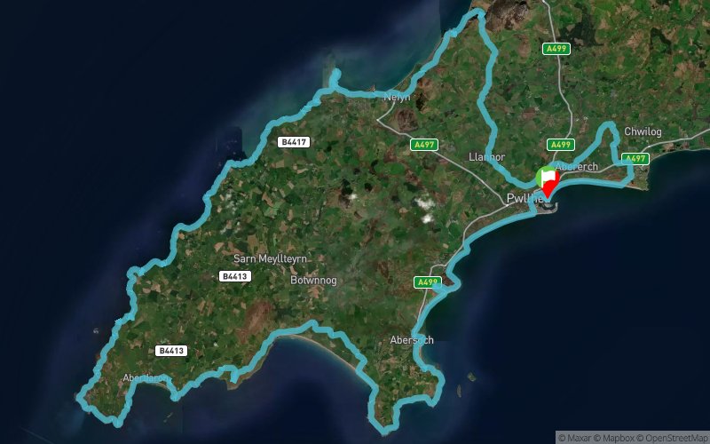
THE PEN LLYN ULTRA MARATHON 2017: AN ULTRA CHALLENGE
THE RACE:
75 miles (121KM) in 24 hours, that is the challenge posed by the second Pen Ll?n Ultra Marathon. The race starts and finishes at Plas Heli in Pwllheli, with 7 checkpoints / aid stations along the scenic route.
THE DATE:
Saturday July 29th, 2017 at 5am.
THE LOCATION:
Tucked away beyond Snowdonia’s craggiest peaks with the Irish Sea on one side and Cardigan Bay on the other, the Ll?n Peninsula has a distinctive, unspoilt character that’s all its own. Its sunny southern coast draws walkers, wakeboarders and dinghy-sailors There are several islands dotted around the peninsula, with the famous ancient pilgrimage site of Bardsey Island, at its tip and can be seen in all its beauty during the race. The islands and coastline of Ll?n are a haven for wildlife and an area of outstanding natural beauty. Seals and dolphins are common sites around the peninsula. All of this makes a perfect back drop for the Pen Ll?n Ultra.
En voir plus... En voir moins...

Start
Distance
0 km
Altitude
10 m
D+
0 m
D-
0 m
124.3 km
1920 m
1920 m
Finish
Distance
124.3 km
Altitude
10 m
D+
1920 m
D-
1920 m
Click on a point of interest to display it on the map
Reviews and times
Add a track
Pen Llyn Ultra 2017

Track number : 38270
Link to track :
https://tracedetrail.fr/en/trace/38270
Log in to insert this track on your website
 Trace de Trail