
Glaciar Trail 2 Heaven
ITRA
 26.81 km
1087 m
1699 m
26.81 km
1087 m
1699 m


Like
Favorites
Reviews
Share
GPX
4
PDF A4
PDF A0
Profile
Flyover
3D
Insert
Passages
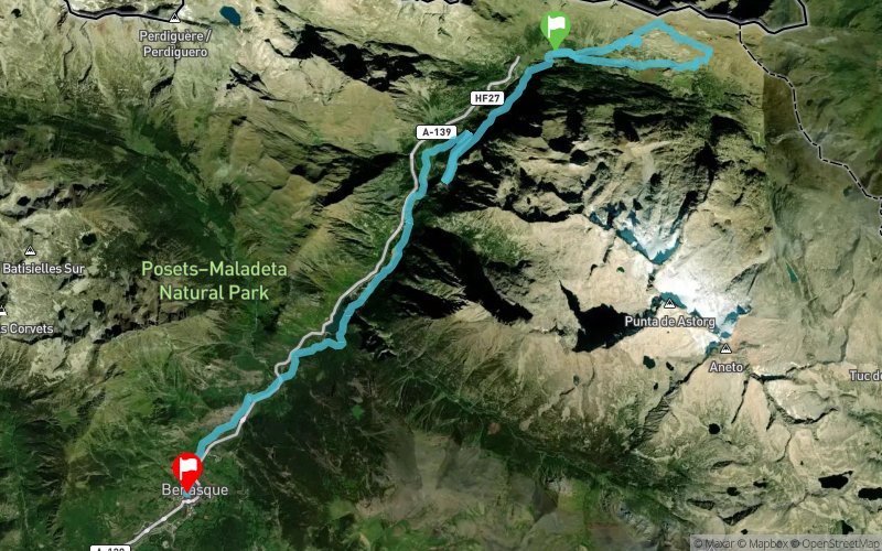
Llanos del Hospital (ES) Benasque (ES)
Effort kilometer
Longest ascent
Longest descent
37
640 m
700 m
Max. elevation
Min. elevation
Quality index
2379 m
1134 m
 1pt/8m
THE GLACIAR TRAIL
26 km in the valley of Benasque while enjoying the views of the glaciers closest to the Equator in Europe.
We start at the base of the cross-country ski resort Los Llanos del Hospital then we run around Los Llanos del Hospital, 26 km and 1000 m of elevation gain, where we almost touch the peaks of the mountains that separate the valleys of Benasque, Arán and Bagnères-de-Luchon (France).
We turn to the north towards France after running over the massif of Maladeta, for ascension to the “Mirador del Aneto", where we are able to enjoy the impressive view of the Maladeta’s massif and its glaciers we just left behind us.
En voir plus... En voir moins...

Start
Distance
0 km
Altitude
1747 m
D+
0 m
D-
0 m
08:00
26.8 km
1087 m
1699 m
Finish
Distance
26.8 km
Altitude
1135 m
D+
1087 m
D-
1699 m
Village
Click on a point of interest to display it on the map
Reviews and times
Add a track
Trail 2 Heaven - Glaciar Trail 2 Heaven

Track number : 331475
Link to track :
https://tracedetrail.fr/en/trace/331475
Log in to insert this track on your website
 Trace de Trail