
Ticino 500
ITRA
 515.43 km
38450 m
38450 m
515.43 km
38450 m
38450 m
Logo Ticino Wildlands 500

Like
10 Favorites
Reviews
Share
GPX
93
PDF A4
PDF A0
Profile
Flyover
3D
Insert
Passages
S. Vittore (CH) S. Vittore (CH)
Effort kilometer
Longest ascent
Longest descent
899
2120 m
2630 m
Max. elevation
Min. elevation
Quality index
2722 m
193 m
 1pt/20m
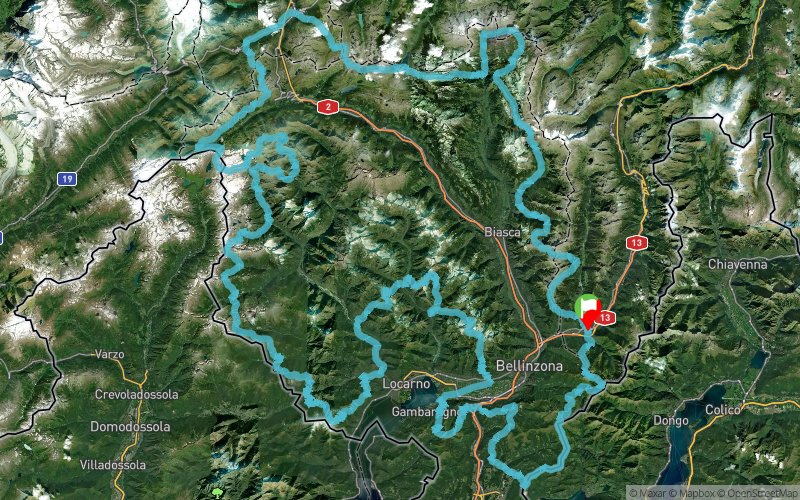
The Ticino 500 is an approximately 500-kilometre route with 40,000 metres of elevation gain, to be covered on foot along the alpine and pre-alpine trails bordering the Canton of Ticino.
It is a self-supported challenge between control points, with no direct external assistance, requiring strong skills in self-management, endurance, and adaptability.
The goal is to experience adventure, exploration, self-discovery, and respect for the mountain environment.
Each participant takes on the challenge under their own responsibility, fully aware of the risks associated with the natural surroundings.
The Ticino 500 is a private sporting raid, not a competitive race.
En voir plus... En voir moins...


Start
Distance
0 km
Altitude
313 m
D+
0 m
D-
0 m
49.4 km
4597 m
3910 m
Laghetto della Val Malvaglia
Distance
49.4 km
Altitude
1002 m
D+
4597 m
D-
3910 m
Food supply
47.9 km
3265 m
3062 m
Campo Blenio
Distance
97.3 km
Altitude
1201 m
D+
7862 m
D-
6972 m
Food supply
49.6 km
2733 m
2390 m
Distance
146.9 km
Altitude
1546 m
D+
10595 m
D-
9362 m
Food supply
56.2 km
4028 m
3260 m
Lago del Narèt
Distance
203.1 km
Altitude
2314 m
D+
14623 m
D-
12622 m
Food supply
48.6 km
3768 m
4575 m
Bosco Gurin
Distance
251.7 km
Altitude
1512 m
D+
18391 m
D-
17197 m
Food supply
42.1 km
3112 m
4027 m
Camedo
Distance
293.8 km
Altitude
588 m
D+
21503 m
D-
21224 m
Food supply
32.4 km
2571 m
2915 m
Golino
Distance
326.2 km
Altitude
248 m
D+
24074 m
D-
24139 m
Food supply
32.9 km
2769 m
2288 m
Brione Verzasca
Distance
359.1 km
Altitude
729 m
D+
26843 m
D-
26427 m
Food supply
52.5 km
4074 m
4605 m
Magadino
Distance
411.6 km
Altitude
197 m
D+
30917 m
D-
31032 m
Food supply
53.2 km
3783 m
3375 m
Villa Luganese
Distance
464.7 km
Altitude
606 m
D+
34700 m
D-
34407 m
Food supply
50.7 km
3750 m
4043 m
Finish
Distance
515.4 km
Altitude
313 m
D+
38450 m
D-
38450 m
Click on a point of interest to display it on the map
Reviews and times
Add a track
Ticino 500 Ticino 500

Track number : 318015
Link to track :
https://tracedetrail.fr/en/trace/318015
Log in to insert this track on your website
 Trace de Trail