
St Cuthbert's Way Ultra 2017 - 45M
ITRA
 73.4 km
1730 m
1740 m
73.4 km
1730 m
1740 m

Like
Favorites
Reviews
Share
GPX
34
PDF A4
PDF A0
Profile
Flyover
3D
Insert
Passages
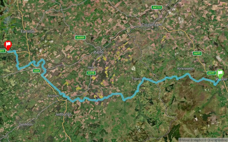
Wooler (GB) Darnick (GB)
Effort kilometer
Longest ascent
Longest descent
90
270 m
320 m
Max. elevation
Min. elevation
Quality index
355 m
54 m
 1pt/10m
Trail Outlaws present Saint Cuthbert's Way Ultra. Bridging the national borders between Scotland and England, this inspiring 45 mile route start at Wooler. The route heads Westwards crossing large sections of the Northumberland National Park and the beautiful Scottish Borders region. Finishing at Melrose, which is where Saint Cuthbert's journey is thought to have started. This reduced mileage route still captures many of the most scenic and undulating sections of the Saint Cuthbert's Way.
En voir plus... En voir moins...

Start
Distance
0 km
Altitude
111 m
D+
0 m
D-
0 m
73.4 km
1726 m
1733 m
Finish
Distance
73.4 km
Altitude
104 m
D+
1726 m
D-
1733 m
Click on a point of interest to display it on the map
Reviews and times
Add a track
St Cuthbert's Way Ultra 2017 - 45M

Track number : 30275
Link to track :
https://tracedetrail.fr/en/trace/30275
Log in to insert this track on your website
 Trace de Trail