
Vuokatti Trail Challenge 2017 - 42 km
ITRA
 41.1 km
1360 m
1410 m
41.1 km
1360 m
1410 m

Like
Favorites
Reviews
Share
GPX
31
PDF A4
PDF A0
Profile
Flyover
3D
Insert
Passages
Laakajärvi (FI) Pohjavaara (FI)
Effort kilometer
Longest ascent
Longest descent
54
160 m
180 m
Max. elevation
Min. elevation
Quality index
372 m
161 m
 1pt/17m
42 km
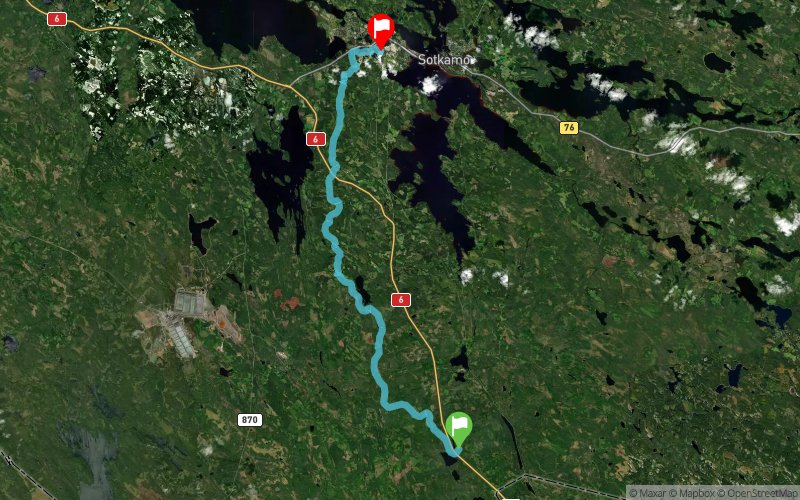
The start of the Vuokatti Trail Challenge 42 km competition is located at the Maanselän Etappi and the finish is at the hotel Vuokatinhovi. The track follows UKK-hiking path and offers great scenery and beautiful wilderness with old boreal forests. Shortly after the Maanselän Etappi there is a long uphill as the track goes over Lappavaara hill area. After that the track is rather even and there are no big climbs before Teerivaara. The condition of the UKK-hiking path gets better in this part of the track and the duckboards and bridges are generally in good condition. The path is also good and easy to run. Wildlife can be seen throughout the Vuokatti Trail Challenge track for example grouse birds like black grouse and capercaillie. After Teerivaara the competition route is the same as the 23 km route (see 23 km route description) and it will lead the runners towards the legendary 13 Hill´s area called Vuokatinvaara which is the great and very hard ending to 42 km track. Sceneries are amazing in this Vuokatinvaara area which will start about 23km before finish.
En voir plus... En voir moins...

Municipality of Sotkamo, Maanselän Etappi
Distance
0 km
Altitude
219 m
D+
0 m
D-
0 m
41.1 km
1357 m
1407 m
Municipality of Sotkamo, Vuokatti Sport Institute
Distance
41.1 km
Altitude
170 m
D+
1357 m
D-
1407 m
Click on a point of interest to display it on the map
Reviews and times
Add a track
Vuokatti Trail Challenge 2017 - 42 km

Track number : 29236
Link to track :
https://tracedetrail.fr/en/trace/29236
Log in to insert this track on your website
 Trace de Trail