
Grand Canyon 2017 - 50 Mile
ITRA
 78.6 km
1150 m
1150 m
78.6 km
1150 m
1150 m

Like
Favorites
Reviews
Share
GPX
27
PDF A4
PDF A0
Profile
Flyover
3D
Insert
Passages
Fredonia (US) Inconnu (US)
Effort kilometer
Longest ascent
Longest descent
90
220 m
240 m
Max. elevation
Min. elevation
Quality index
2795 m
2278 m
 1pt/14m
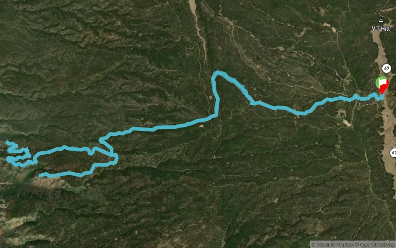
The 50 mile route is a point-to-point race starting at the height of the Kaibab Plateau (9000ft) at 6am on Saturday. Runners will descend 2,000ft down to the rim of the canyon, where they will run the Rainbow Rim trail singletrack to 5 overlook points before a rugged traverse on old logging roads over to the spectacular Crazy Jug and Monument Point overlooks into the Grand Canyon. The route then finishes at a historic corral (Big Saddle Tank) once used by ranchers on the plateau.
En voir plus... En voir moins...

Start
Distance
0 km
Altitude
2678 m
D+
0 m
D-
0 m
78.6 km
1150 m
1150 m
Finish
Distance
78.6 km
Altitude
2678 m
D+
1150 m
D-
1150 m
Click on a point of interest to display it on the map
Reviews and times
Add a track
Grand Canyon 2017 - 50 Mile

Track number : 29006
Link to track :
https://tracedetrail.fr/en/trace/29006
Log in to insert this track on your website
 Trace de Trail