
PYT120
ITRA
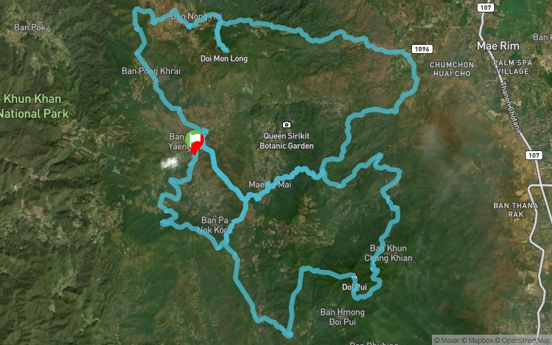
 119.61 km
6284 m
6284 m
119.61 km
6284 m
6284 m

Like
1 Favorites
Reviews
Share
GPX
14
PDF A4
PDF A0
Profile
Flyover
3D
Insert
Passages
Weang Hang (TH) Weang Hang (TH)
Effort kilometer
Longest ascent
Longest descent
182
1170 m
1230 m
Max. elevation
Min. elevation
Quality index
1678 m
337 m
 1pt/9m
For those who wish to avoid tackling a hundred-miler, PYT120 is an excellent alternative to PYT100. You will start in the evening, a unique twist compared to the early start of PYT100.
The first half of the course is the same as RTC50, a familiar challenge for some, followed by the second half, which shares the the route with PYT70.
Doing a PYT120 means you can expect long climbs, high peaks, and extra fun, making for a truly unique and intriguing experience.
En voir plus... En voir moins...

Start
Distance
0 km
Altitude
782 m
D+
0 m
D-
0 m
119.6 km
6284 m
6284 m
Finish
Distance
119.6 km
Altitude
782 m
D+
6284 m
D-
6284 m
Click on a point of interest to display it on the map
Reviews and times
Add a track
Pong Yaeng Trail PYT120

Track number : 262546
Link to track :
https://tracedetrail.fr/en/trace/262546
Log in to insert this track on your website
 Trace de Trail