
Madruk Trail - 27km
ITRA
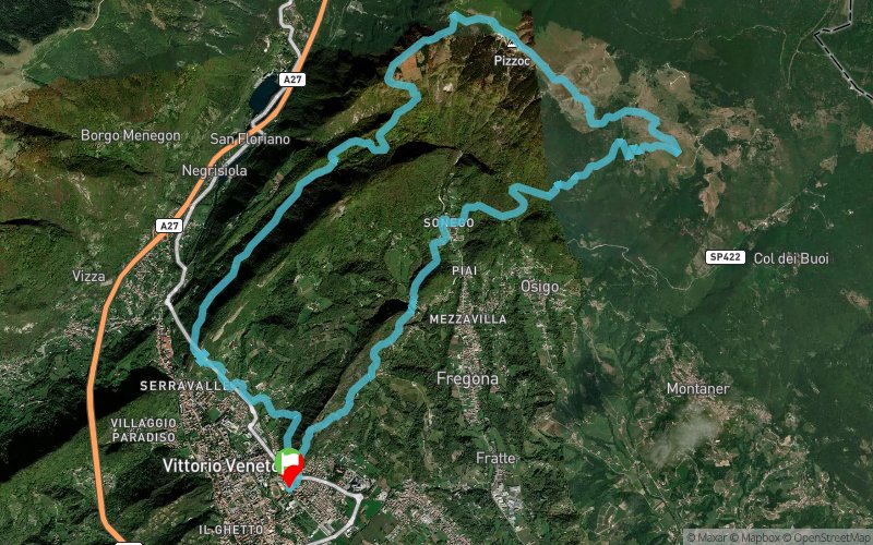
 27.7 km
1810 m
1810 m
27.7 km
1810 m
1810 m

Like
Favorites
Reviews
Share
GPX
PDF A4
PDF A0
Profile
Flyover
3D
Insert
Passages
via de Nadai, 4, Vittorio Veneto (IT) via de Nadai, 4, Vittorio Veneto (IT)
Effort kilometer
Longest ascent
Longest descent
45
1490 m
1000 m
Max. elevation
Min. elevation
Quality index
1566 m
124 m
 1pt/6m
The Madruk Trail is a race of approximately 27 km with a positive elevation gain of about 1,800 meters, starting from the area near Via de Nadai, 4, in Vittorio Veneto (Italy). This competition offers a challenging course through the forests of Vittorio Veneto, showcasing the magnificent spring hues of the Venetian Prealps. It is a trail characterized by a certain level of technical difficulty, primarily due to rocky areas. The terrain type varies from narrow forest paths to wider forest roads, encompassing gravel, soil, and paved roads.
En voir plus... En voir moins...

Start
Distance
0 km
Altitude
125 m
D+
0 m
D-
0 m
27.7 km
1810 m
1810 m
Finish
Distance
27.7 km
Altitude
125 m
D+
1810 m
D-
1810 m
Click on a point of interest to display it on the map
Reviews and times
Warning ! This track is only accessible on the day of the competition
Add a track
Madruk Trail Madruk Trail - 27km

Track number : 244726
Link to track :
https://tracedetrail.fr/en/trace/244726
Log in to insert this track on your website
 Trace de Trail