
Vucko trail RED 2023
ITRA
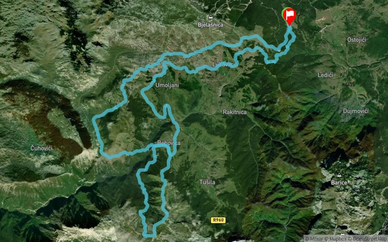
 59.29 km
3200 m
3198 m
59.29 km
3200 m
3198 m

Like
Favorites
Reviews
Share
GPX
10
PDF A4
PDF A0
Profile
Flyover
3D
Insert
Passages
Vid (HR) Vid (HR)
Effort kilometer
Longest ascent
Longest descent
91
1040 m
900 m
Max. elevation
Min. elevation
Quality index
1918 m
1004 m
 1pt/16m
This is a trail where we had to take a great care where to go so that elevation gain does not exceed +4000m. The other side of Bjelasnica, ancient roads and even more ancient legends, the Rakitnica canyon and the knife-sharp ridge of mountain Visocica. And all that spiced with breathtaking landscapes and stecak tombstones popping up all around. It is irresistibly reminiscent of our ancestors who would do this trail for breakfast while chasing sheep across mountain slopes.
En voir plus... En voir moins...
Track created by PLANINARSKO DRUTVO ŽELJEZNI?AR
le 2023/04/16 (modified on 2023/04/18)
le 2023/04/16 (modified on 2023/04/18)


Javorov Do
Distance
0 km
Altitude
1253 m
D+
0 m
D-
0 m
11.7 km
673 m
336 m
Crveni klanac
Distance
11.7 km
Altitude
1590 m
D+
673 m
D-
336 m
6.4 km
184 m
314 m
Lukomir
Distance
18.1 km
Altitude
1460 m
D+
857 m
D-
650 m
5.1 km
296 m
460 m
Bobovica 1
Distance
23.2 km
Altitude
1296 m
D+
1153 m
D-
1110 m
14.8 km
1145 m
1134 m
Bobovica 2
Distance
38 km
Altitude
1307 m
D+
2298 m
D-
2244 m
6.7 km
383 m
203 m
Gradina
Distance
44.7 km
Altitude
1486 m
D+
2681 m
D-
2447 m
7.2 km
263 m
366 m
Lukavac
Distance
51.8 km
Altitude
1383 m
D+
2944 m
D-
2813 m
7.4 km
256 m
385 m
Javorov Do
Distance
59.3 km
Altitude
1255 m
D+
3200 m
D-
3198 m
Click on a point of interest to display it on the map
Reviews and times
Add a track
Vucko trail RED 2023

Track number : 216396
Link to track :
https://tracedetrail.fr/en/trace/216396
Log in to insert this track on your website
 Trace de Trail