
Lavaredo Ultra Trail 2022 - Cortina Skyrace
 20.6 km
1310 m
1310 m
20.6 km
1310 m
1310 m
23/06/2022
Like
Favorites
Reviews
Share
GPX
25
PDF A4
PDF A0
Profile
Flyover
3D
Insert
Passages
Cortina D'Ampezzo (IT) Cortina D'Ampezzo (IT)
Effort kilometer
Longest ascent
Longest descent
33
520 m
1010 m
Max. elevation
Min. elevation
Quality index
2117 m
1208 m
 1pt/6m
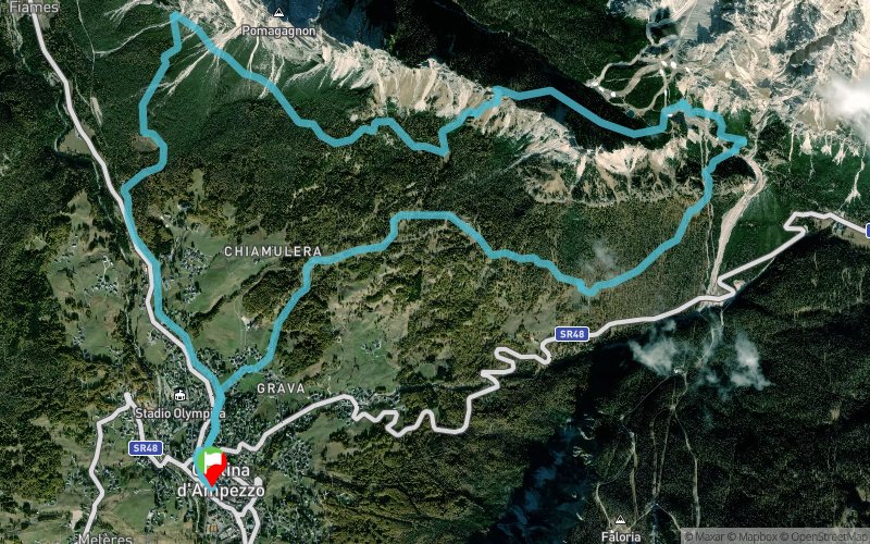
20 km 1.000 m+ The Cortina Skyrace departs and arrives from the center of Cortina and allows you to discover from high altitude the entire Ampezzo valley. Fork Zumeles, the highest point of the route, must be won by climbing steep grassy and rocky slopes, but gives a fantastic view of Cortina and the mountains that surround it: Cristallo, Tofane, Cinque Torri, up to Pelmo, Civetta and Marmolada.
En voir plus... En voir moins...

Start
Distance
0 km
Altitude
1222 m
D+
0 m
D-
0 m
20.6 km
1310 m
1310 m
Finish
Distance
20.6 km
Altitude
1222 m
D+
1310 m
D-
1310 m
Click on a point of interest to display it on the map
Reviews and times
Add a track
Lavaredo Ultra Trail 2022 - Cortina Skyrace

Track number : 165452
Link to track :
https://tracedetrail.fr/en/trace/165452
Log in to insert this track on your website
 Trace de Trail