
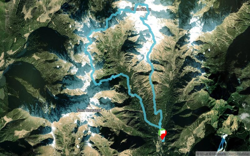
Cima d'Asta Skyrace - 27 km
ITRA
 26.8 km
2260 m
2260 m
26.8 km
2260 m
2260 m

Like
Favorites
Reviews
Share
GPX
7
PDF A4
PDF A0
Profile
Flyover
3D
Insert
Passages
Pieve Tesino (IT) Pieve Tesino (IT)
Effort kilometer
Longest ascent
Longest descent
49
1330 m
1780 m
Max. elevation
Min. elevation
Quality index
2800 m
1112 m
 1pt/16m
La Cima d'Asta Skyrace è una gara di corsa in montagna che si svolge sul massiccio di Cima d'Asta, nel cuore del Lagorai in Trentino (IT). Sono previsti due percorsi differenti: - Estremo: 27 km con un dislivello positivo di 2400 metri; - Corto: 16 km con un dislivello positivo di 1200 metri. Il percorso estremo porta sulla vetta di Cima d'Asta (2847 m), percorrendo il Canalone Bassanesi e la cresta Ovest con passaggi esposti a strapiombo sul lago di Cima d’Asta.
En voir plus... En voir moins...
Track created by Skiteamlagorai
le 2021/07/26 (modified on 2021/08/02)
le 2021/07/26 (modified on 2021/08/02)

Start
Distance
0 km
Altitude
1113 m
D+
0 m
D-
0 m
26.8 km
2260 m
2260 m
Finish
Distance
26.8 km
Altitude
1113 m
D+
2260 m
D-
2260 m
Click on a point of interest to display it on the map
Reviews and times
Add a track
Cima d'Asta Skyrace - 27 km

Track number : 156650
Link to track :
https://tracedetrail.fr/en/trace/156650
Log in to insert this track on your website
 Trace de Trail