
Northburn 100 Miler 2016 - 100 Mile
ITRA
 155.8 km
8230 m
8230 m
155.8 km
8230 m
8230 m

Like
Favorites
Reviews
Share
GPX
25
PDF A4
PDF A0
Profile
Flyover
3D
Insert
Passages
Cromwell (NZ) Inconnu (NZ)
Effort kilometer
Longest ascent
Longest descent
238
1620 m
1130 m
Max. elevation
Min. elevation
Quality index
1661 m
149 m
 1pt/16m
Yes! The 100miler is all on for 2016!!
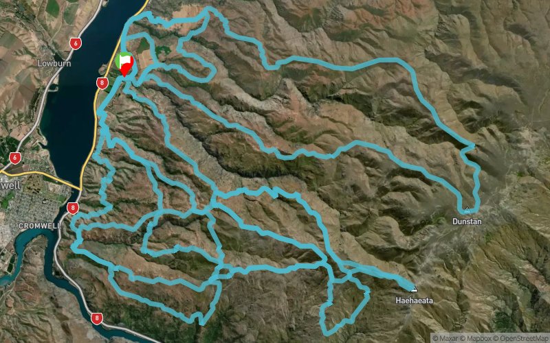
100 miles is 161km folks, and this course will have you climbing and descending around 10,000m (32,808feet). That's a good honest effort.
Click the maps below to view as Jpegs or down load the google earth files from the Course Profiles tab above. The 100mile (161km) course covers 3 maps, each loop starts and finishes in the same place - great to catch up with your supporters!
The first 50km loop take you from 200m above sea level (Start/finish) up near the most central point in New Zealand at around 1660m (2600m vertical climb). The second 'loop' is another 50km loop with a climb of 3750m. The third and final loop is only 10ks longer but still with steep climbs distributed through it (4000m vertical climb). Total climb of over 9000m.
There will be plenty of marshals along key areas of the course. The course will be well marked with directional arrows, plastic poles and reflective tape at night. There will be one aid station about half way round each loop with nutrition and electrolyte supplements. You will also be coming back through the start/finish area at the 50k and 100k marks so you will be able to pick up your personal refreshments/gear as required. There will be some extra fresh water re-fill positions (creeks) along the course so a water carrying capacity of about 2L per person should be adequate. There will be some compulsory re-fill points.
This is a dry, hard, rocky course mostly run over high country 4WD tracks but also including some short sections of fence lines and sheep tracks. The weather can be 'changeable' so your minimum gear must be carried at all times.
En voir plus... En voir moins...

Start
Distance
0 km
Altitude
222 m
D+
0 m
D-
0 m
155.8 km
8230 m
8230 m
Finish
Distance
155.8 km
Altitude
222 m
D+
8230 m
D-
8230 m
Click on a point of interest to display it on the map
Reviews and times
Add a track
Northburn 100 Miler 2016 - 100 Mile

Track number : 15219
Link to track :
https://tracedetrail.fr/en/trace/15219
Log in to insert this track on your website
 Trace de Trail