
Bettelmatt Trail 2016 - 83 km
ITRA
 82.9 km
5080 m
4610 m
82.9 km
5080 m
4610 m

Like
Favorites
Reviews
Share
GPX
60
PDF A4
PDF A0
Profile
Flyover
3D
Insert
Passages
Formazza (IT) Formazza (IT)
Effort kilometer
Longest ascent
Longest descent
133
1280 m
870 m
Max. elevation
Min. elevation
Quality index
2919 m
1282 m
 1pt/8m
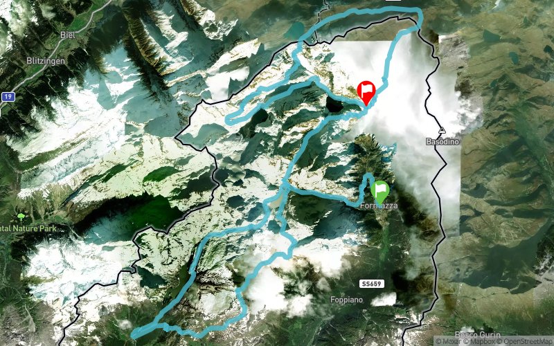
Un percorso di ben 83 km, per un dislivello positivo totale di 4.552 m, che da Ponte, il "capoluogo" del Comune di Formazza, porterà gli atleti fino all'Alpe Devero per poi arrivare a Riale - sede storica di partenza e arrivo della Sky Race - compiere il giro della classica 33 km, compreso il passaggio ai 3.000 del Rifugio 3A, per poi concludersi nella magnifica conca di Riale.
En voir plus... En voir moins...

Start
Distance
0 km
Altitude
1282 m
D+
0 m
D-
0 m
82.9 km
5071 m
4601 m
Finish
Distance
82.9 km
Altitude
1752 m
D+
5071 m
D-
4601 m
Click on a point of interest to display it on the map
Reviews and times
Add a track
Bettelmatt Trail 2016 - 83 km

Track number : 14886
Link to track :
https://tracedetrail.fr/en/trace/14886
Log in to insert this track on your website
 Trace de Trail