
Pong Yaeng Trail 66 [2015]
ITRA
 67.4 km
3280 m
3280 m
67.4 km
3280 m
3280 m


Like
Favorites
Reviews
Share
GPX
110
PDF A4
PDF A0
Profile
Flyover
3D
Insert
Passages
Queen Sirikit Botanic Garden (TH) 0 (0)
Effort kilometer
Longest ascent
Longest descent
100
820 m
500 m
Max. elevation
Min. elevation
Quality index
1440 m
619 m
 1pt/11m
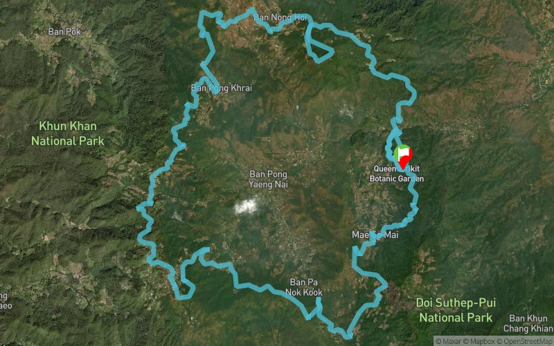
an ultra-distance trail race starting from the iconic Glasshouse Complex of QSBG which takes runners along the old trail of Pong Yaeng – first heading up to the ancient landmark of Mon Lhong then down and up to Pong Krai winding back to the foothills of Doi Suthep & Doi Pui through many villages before returning to the QSBG from the South entrance.
En voir plus... En voir moins...

QSBG
Distance
0 km
Altitude
970 m
D+
0 m
D-
0 m
67.4 km
3280 m
3280 m
Finish
Distance
67.4 km
Altitude
970 m
D+
3280 m
D-
3280 m
Click on a point of interest to display it on the map
Reviews and times
Add a track
Pong Yaeng Trail 66 [2015]

Track number : 14170
Link to track :
https://tracedetrail.fr/en/trace/14170
Log in to insert this track on your website
 Trace de Trail