Afficher la carte
Trace évaluée - ITRA
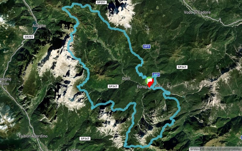
Dolomiti Extreme Trail 2020 - 72K


73.1 km
4930 m
4930 m
 Forno Di Zoldo (IT)
 9
9 370
370
72 kilometres of pure challenge. After the emotions you will experience and suffer on this route, after knowing the wild spirit and magnificence of our dolomites, you will come to love these peaks and you will bring on the next extreme challenge, that of the 103k, no doubt!
The 72 kilometre route starts on the track the 103k, immediately hitting the mountainous group of Spiz di Mezzodi ', while discovering wild and uncontaminated territories. With the arrival at the Pramperet refuge (km 15.8, refreshment point 1 - 1857 m) you will enter the Dolomiti Bellunesi National Park, to then continue at the base of the peaks of the Tamer - S.Sebastiano, where you will need to climb steeply, as goats do, from the suggestive Vach lake. There you will meet the route of the 53k and will continue along that same path, to arrive at the rifugio San Sebastiano on the Duran pass (km 30.0 - refreshment point 2 - 1605 m). The pass marks a change of environment, the Moiazza and the Civetta mountains being colossal rocky sequences of the Dolomites.
Large glacial cirques alternate with "solitary furrowed fields". It will be incredibly solemn and extremely exciting to travel along the gigantic base of the "Grande Civetta" to the Coldai refuge (km 43.8 - refreshment point 4 - 2135 m) and then descend to the refreshment area at the Passo Staulanza refuge (km 54, refreshment point 6 - 1766 m) .
The route then runs on to the base of monte Pelmo, isolated and grandiose. Your view will be polarized towards it, as it is considered amongst the most fascinating and singular Dolomites mountains, in some ways unique.
Leaving the pastures at the foot of the Pelmo and the route of the 103k, the route descends to passo Tamai (km 62 - refreshment point - 1715 m) to then go up to the spectacular panoramic point of monte Punta (km 66 - 1952 m). With the feeling of being in the center of a dolomitic paradise, your view will be filled with all the peaks crossed on the day. Full of pride, you will descend to the starting point and the finishing line ... But not without first agreeing with us that while admiring the Bosconero to the south, you will decide that the challenge for next year will have to be the 103k route!
Table des passages
| Cumul | Intermédiaire | |||||||
|---|---|---|---|---|---|---|---|---|
| Passage | Description | Alt. | Dist. | D+ | D- | Dist. | D+ | D- |
 Compétition organisée le 12/06/2020
Trace n°98688
Seuil de dénivelé : 3 m Seuil de distance : 30 m Lissage : Oui Origine des altitudes : MNT Google
Seuil de dénivelé : 3 m Seuil de distance : 30 m Lissage : Oui Origine des altitudes : MNT Google
Boucle
Terrain dominant : Sentier
Alti. max. : 2386 m
Alti. moyenne : 1625 m
Alti. min. : 803 m
+ longue montée : 880 m
+ longue descente : 1020 m
Terrain dominant : Sentier
Alti. max. : 2386 m
Alti. moyenne : 1625 m
Alti. min. : 803 m
+ longue montée : 880 m
+ longue descente : 1020 m
Profils altimétriques
Plus d'outils
Créer une page de roadbook
Carte et profil sur votre site web
Attention ! En insérant une carte Trace de Trail sur votre site web, vous vous engagez à ne masquer aucun élément du module (liens vers Trace de Trail ou bannière Trail Connect), que ce soit en utilisant l'iframe ou le widget.
Ajouter une réalisation
Valider
Ajoutez une réalisation pour partager votre chrono et détailler les conditions que vous avez recontrées lors de votre sortie trail !
Ajouter un commentaire
Valider
Afficher les infos
Ajouter une trace


