Afficher la carte
Trace évaluée - ITRA
Dolomiti Extreme Trail 2022 - 103K


100.5 km
6940 m
6940 m
 Forno Di Zoldo (IT)
 9
9 390
390
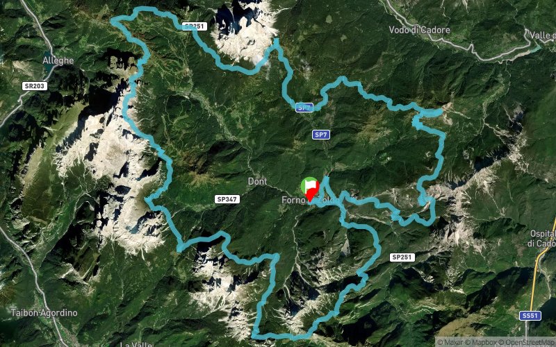
103 kilometres of adventure and courage, an adventure that will give you many emotions, different emotions, unforgettable emotions, and the courage that comes with the pride of having made it. The DXT103k is not just any trail, it is the famous round-route of the Val di Zoldo!!!
The route starts by immediately hitting the mountain range of Spiz di Mezzodì' and discovering wild and uncontaminated areas. On arrival at the Pramperet refuge (km 15., refreshment point 1 - 1857 m) you enter the Dolomiti Bellunesi National Park, to then continue along the base of the peaks of the Tamer - S.Sebastiano, where you will need to climb steeply, as goats do, from the suggestive Vach lake. There you will meet the route of the 53k and will continue along that same path, to arrive at the rifugio San Sebastiano on the Duran pass (km 30.0 - refreshment point 2 - 1605 m). The pass marks a change of environment, the Moiazza and the Civetta mountains being colossal rocky sequences of the Dolomites.
Large glacial cirques alternate with "solitary furrowed fields". It will be incredibly solemn and extremely exciting to travel along the gigantic base of the "Grande Civetta" to the Coldai refuge (km 43.8 - refreshment point 4 - 2135 m) and then descend to the refreshment area at the Passo Staulanza refuge (km 54, refreshment point 6 - 1766 m) .
The route then heads to the base of monte Pelmo, isolated and grandiose. Your view will be polarized towards it, as it is considered amongst the most fascinating and singular Dolomites mountains, in some ways unique.
The route continues to Zoppè di Cadore (km 66 - refreshment point 8 - 1462 m) and to the talamini refuge (km 70 - refreshment point 9 - 1582 m) to reach, on top of mount Rite, the Museum in the clouds - Reinhold Messner Mountain Museum – where the rifugio Dolomites is located (76 km - refreshment point 10 - 2160 m).
Leaving passo Cibiana, the route climbs up until it comes face to face with the Bosconero group, the incredible rocky fan of the Sfornioi, the vertical corners of Rocchetta and Sasso di Tovanella. It then literally descends again into the wild Dolomites towards the rifugio Casera di Bosconero (km 90 - refreshment point 12 - 1457 m). From here, you will be able to see the Spiz di Mezzodì', the same peaks that were crossed at the very start of the race. You will be able to view the valley winding at your feet and the last descent on the Fagarè Nature Trail. On reaching the end of the route, you will be happy to have achieved and completed one of the most extreme routes, that of the Val di Zoldo Dolomites ring, arriving back at your starting point in Forno di Zoldo.
Table des passages
| Cumul | Intermédiaire | |||||||
|---|---|---|---|---|---|---|---|---|
| Passage | Description | Alt. | Dist. | D+ | D- | Dist. | D+ | D- |
 Compétition organisée le 10/06/2022
Trace n°82222
Seuil de dénivelé : 0 m Seuil de distance : 30 m Lissage : Oui Origine des altitudes : MNT Google
Seuil de dénivelé : 0 m Seuil de distance : 30 m Lissage : Oui Origine des altitudes : MNT Google
Boucle
Terrain dominant : Sentier
Alti. max. : 2386 m
Alti. moyenne : 1623 m
Alti. min. : 806 m
+ longue montée : 920 m
+ longue descente : 730 m
Terrain dominant : Sentier
Alti. max. : 2386 m
Alti. moyenne : 1623 m
Alti. min. : 806 m
+ longue montée : 920 m
+ longue descente : 730 m
Plus d'outils
Créer une page de roadbook
Carte et profil sur votre site web
Attention ! En insérant une carte Trace de Trail sur votre site web, vous vous engagez à ne masquer aucun élément du module (liens vers Trace de Trail ou bannière Trail Connect), que ce soit en utilisant l'iframe ou le widget.
Ajouter une réalisation
Valider
Ajoutez une réalisation pour partager votre chrono et détailler les conditions que vous avez recontrées lors de votre sortie trail !
Ajouter un commentaire
Valider
Afficher les infos
Ajouter une trace


