Afficher la carte
Trace certifiée - ITRA
La Corsa della Bora 2018 - S1 Ipertrail 167 km
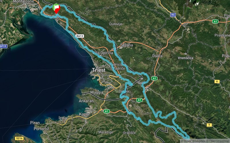


 Sistiana (IT)


A perfect ring, starting by the sea, first along the Gulf of Trieste, then to enter the highlands of the Bora wind, to reach the snowy Mount Slavnik, running on the border ridge between Italy and Slovenia, between Slovenia and Croatia and coming back to Italy on the CAI 3, who became famous for the “Cavalcata Carsica”.
“The wildest and most Resilient Endurance Run”
logo-s1-iper_90 A continuous alteration of fast sections, breathtaking views of the Gulf of Trieste and steep paths in the magical and wild beech forests of Slovenia. A trail that embodies all the variety of landscapes and terrain, from the dry limestone and Dolomite to the snowy peaks of Slovenia. Sections where navigation takes place following the ridges and with GPS along with wild slopes which then lead to easy tracks. Each section is a surprise, every kilometer a challenge in adaptation.
The route will be marked in the main points, the marked trails with hiking signs, but the use of GPS is required. If there is snow, strong winds or adverse conditions may be the only way not to get lost.
Table des passages
| Cumul | Intermédiaire | |||||||
|---|---|---|---|---|---|---|---|---|
| Passage | Description | Alt. | Dist. | D+ | D- | Dist. | D+ | D- |
 Compétition organisée le 06/01/2018
Trace n°45050
Seuil de dénivelé : 3 m Seuil de distance : 0 m Lissage : Non Origine des altitudes : GPS
Seuil de dénivelé : 3 m Seuil de distance : 0 m Lissage : Non Origine des altitudes : GPS
Boucle
Terrain dominant : Sentier
Alti. max. : 1064 m
Alti. moyenne : 416 m
Alti. min. : -6 m
+ longue montée : 540 m
+ longue descente : 680 m
Terrain dominant : Sentier
Alti. max. : 1064 m
Alti. moyenne : 416 m
Alti. min. : -6 m
+ longue montée : 540 m
+ longue descente : 680 m
Profils altimétriques
Plus d'outils
Créer une page de roadbook
Carte et profil sur votre site web
Attention ! En insérant une carte Trace de Trail sur votre site web, vous vous engagez à ne masquer aucun élément du module (liens vers Trace de Trail ou bannière Trail Connect), que ce soit en utilisant l'iframe ou le widget.
Ajouter une réalisation
Valider
Ajoutez une réalisation pour partager votre chrono et détailler les conditions que vous avez recontrées lors de votre sortie trail !
Ajouter un commentaire
Valider
Afficher les infos
Ajouter une trace


