Show the map
Col Sarenne-Col Souchet-Col d'Arsine-Eychauda-Col Aup Martin-Col Cote Belle-Col Romeïou-Lauvitel
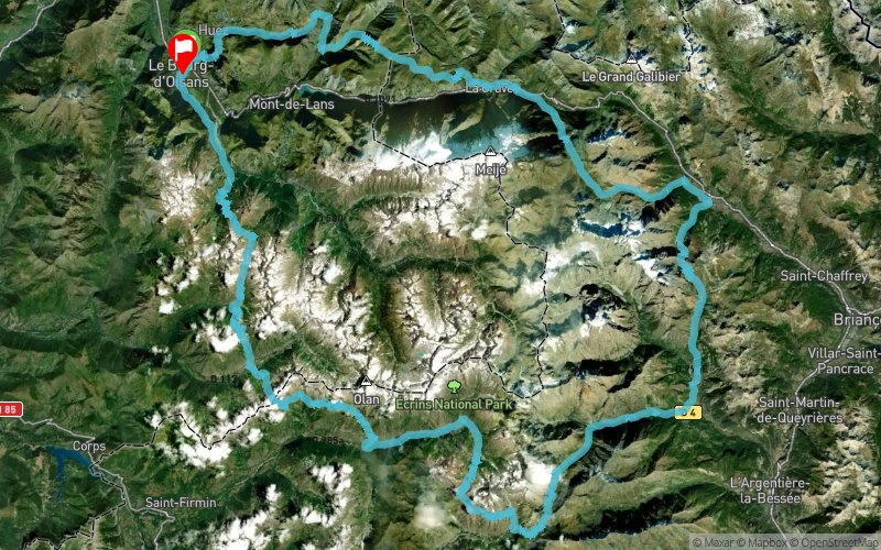


191.3 km
12680 m
12680 m
 Le Bourg-d’Oisans (38)
 Le Bourg-d’Oisans (38)
 Points of Interest table
| Accum. | Intermediary | |||||||
|---|---|---|---|---|---|---|---|---|
| POI | Description | Alt. | Dist. | D+ | D- | Dist. | D+ | D- |
Trace n°98305
Ascent threshold : 3 m Distance threshold : 30 m Smoothing : Yes Origin of altitudes : MNT Aster GDEM
Ascent threshold : 3 m Distance threshold : 30 m Smoothing : Yes Origin of altitudes : MNT Aster GDEM
Loop
Dominant terrain : Footpath
Max alti. : 2756 m
Avg alti. : 0 m
Min alti. : 711 m
Longest ascent : 1560 m
Longest descent : 2150 m
Route completed by the author : No
Dominant terrain : Footpath
Max alti. : 2756 m
Avg alti. : 0 m
Min alti. : 711 m
Longest ascent : 1560 m
Longest descent : 2150 m
Route completed by the author : No
Elevation profile
More tools
Create a new roadbook page
Map and track on your website
Warning ! When you insert a Trace de Trail map on your website, you agree not to hide any element of the module (links to Trail Trail or Trail Connect banner)
Add a realisation
Validate
Add a realisation to share your chrono and describe the conditions that you encountered during you trail running !
Add a comment
Validate
Admin - Trace de Trail
26/09/19, 07:06:46
Bonjour, Merci de respecter les règles de nommage du site avant de placer votre trace en public : https://tracedetrail.com/fr/accueil/help/alire
26/09/19, 07:06:46
Bonjour, Merci de respecter les règles de nommage du site avant de placer votre trace en public : https://tracedetrail.com/fr/accueil/help/alire
Show the infos
Add a track


