Show the map
Bora, Bike and Fun 2020
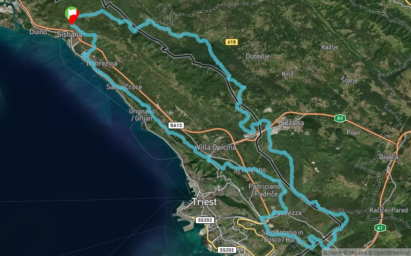


90 km
2170 m
2170 m
 Visogliano (IT)
 Points of Interest table
| Accum. | Intermediary | |||||||
|---|---|---|---|---|---|---|---|---|
| POI | Description | Alt. | Dist. | D+ | D- | Dist. | D+ | D- |
 Event off organized on 01/05/2020
Trace n°97198
Ascent threshold : 0 m Distance threshold : 30 m Smoothing : Yes Origin of altitudes : MNT Aster GDEM
Ascent threshold : 0 m Distance threshold : 30 m Smoothing : Yes Origin of altitudes : MNT Aster GDEM
Loop
Dominant terrain : Path
Max alti. : 670 m
Avg alti. : 313 m
Min alti. : 96 m
Longest ascent : 700 m
Longest descent : 490 m
Dominant terrain : Path
Max alti. : 670 m
Avg alti. : 313 m
Min alti. : 96 m
Longest ascent : 700 m
Longest descent : 490 m
Elevation profile
More tools
Create a new roadbook page
Map and track on your website
Warning ! When you insert a Trace de Trail map on your website, you agree not to hide any element of the module (links to Trail Trail or Trail Connect banner)
Add a realisation
Validate
Add a realisation to share your chrono and describe the conditions that you encountered during you trail running !
Add a comment
Validate
Admin - Trace de Trail
13/09/19, 20:58:41
Bonjour, Merci de réserver le label Officiel aux compétitions.
13/09/19, 20:58:41
Bonjour, Merci de réserver le label Officiel aux compétitions.
Show the infos
Add a track


