Show the map
Le Baptieu - Tête de la Combaz - Mont Joly - Porcherey
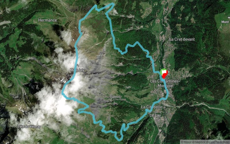


16.3 km
1510 m
1510 m
 Les Contamines-Montjoie (74)
 Points of Interest table
| Accum. | Intermediary | |||||||
|---|---|---|---|---|---|---|---|---|
| POI | Description | Alt. | Dist. | D+ | D- | Dist. | D+ | D- |
Trace n°87917
Ascent threshold : 3 m Distance threshold : 30 m Smoothing : Yes Origin of altitudes : MNT Aster GDEM
Ascent threshold : 3 m Distance threshold : 30 m Smoothing : Yes Origin of altitudes : MNT Aster GDEM
Loop
Dominant terrain : Footpath
Max alti. : 2506 m
Avg alti. : 1739 m
Min alti. : 1124 m
Longest ascent : 1390 m
Longest descent : 1450 m
Route completed by the author : No
Dominant terrain : Footpath
Max alti. : 2506 m
Avg alti. : 1739 m
Min alti. : 1124 m
Longest ascent : 1390 m
Longest descent : 1450 m
Route completed by the author : No
Elevation profile
More tools
Create a new roadbook page
Map and track on your website
Warning ! When you insert a Trace de Trail map on your website, you agree not to hide any element of the module (links to Trail Trail or Trail Connect banner)
Add a realisation
Validate
Add a realisation to share your chrono and describe the conditions that you encountered during you trail running !
Add a comment
Validate
Admin - Trace de Trail
26/05/19, 21:46:48
Bonjour, Merci d'améliorer la qualité de votre trace avant de la placer en public.
26/05/19, 21:46:48
Bonjour, Merci d'améliorer la qualité de votre trace avant de la placer en public.
Show the infos
Add a track


