Show the map
Evaluated Track - ITRA
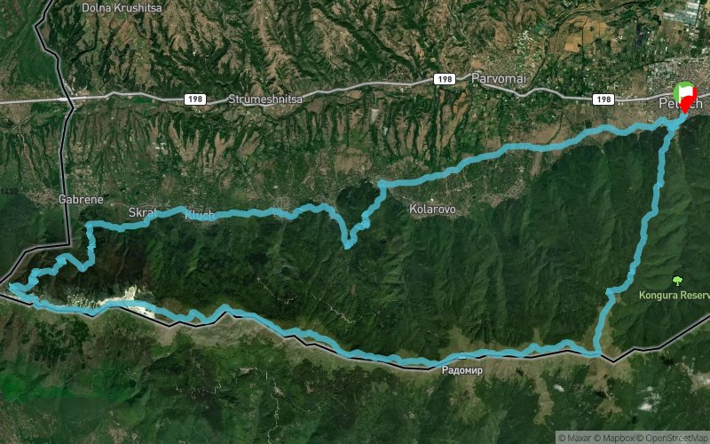
Belasitsa Sky Run 2019


 ?????? / Petrich (BG)


Belasitsa Sky Run is a trail running race that follows the ridge of one of the mountains with the most beautiful panoramas on the Balkan Peninsula.
During the event the participants will enjoy views of three countries (Bulgaria, FYR Macedonia and Greece) and will see the three highest mountains on the Balkans (Rila, Olympus and Pirin). Two beautiful lakes (Dojran and Kerkini) make the panoramas even more breathtaking, while Struma River valley and the picturesque villages at the foot of the Mountain add to the atmosphere of the race part of which runs in midst of the centuries-old chestnut forests - the symbol of Belasitsa Mountain.
The route of Belasitsa Sky Run is 67,4 km long, has an altitude gain of 2800 meters and starts from Petrich, passes along the villages at the foothills of the Mountain, climbs to the Shy waterfall and continues west to the Macedonian border before climbing to the main Mountain ridge and afterwards follows the whole Bulgarian part of the panoramic ridge to the highest peak of Belasitsa - Radomir (2029 m.a.s.l.) to Kongur Peak and descends through centuries-old beech and chestnut forests to the finish in Petrich.
Points of Interest table
| Accum. | Intermediary | |||||||
|---|---|---|---|---|---|---|---|---|
| POI | Description | Alt. | Dist. | D+ | D- | Dist. | D+ | D- |
 Competition organized on 10/05/2019
Trace n°84758
Ascent threshold : 3 m Distance threshold : 30 m Smoothing : Yes Origin of altitudes : MNT Google
Ascent threshold : 3 m Distance threshold : 30 m Smoothing : Yes Origin of altitudes : MNT Google
Loop
Dominant terrain : Footpath
Max alti. : 2008 m
Avg alti. : 1065 m
Min alti. : 184 m
Longest ascent : 1940 m
Longest descent : 1720 m
Dominant terrain : Footpath
Max alti. : 2008 m
Avg alti. : 1065 m
Min alti. : 184 m
Longest ascent : 1940 m
Longest descent : 1720 m
Elevation profile
More tools
Create a new roadbook page
Map and track on your website
Warning ! When you insert a Trace de Trail map on your website, you agree not to hide any element of the module (links to Trail Trail or Trail Connect banner)
Add a realisation
Validate
Add a realisation to share your chrono and describe the conditions that you encountered during you trail running !
Add a comment
Validate
Show the infos
Add a track


