Show the map
Championnat du Canigou 2018
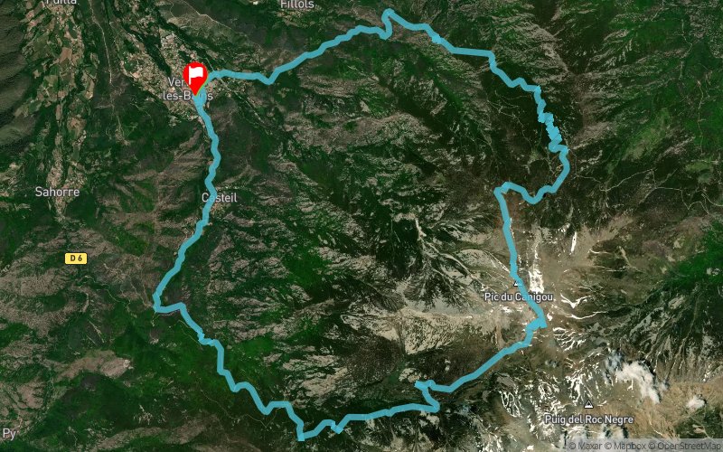


34.3 km
2460 m
2460 m
 Vernet-les-Bains (66)
 Vernet-les-Bains (66)
 Points of Interest table
| Accum. | Intermediary | |||||||
|---|---|---|---|---|---|---|---|---|
| POI | Description | Alt. | Dist. | D+ | D- | Dist. | D+ | D- |
 Competition organized on 08/05/2018
Trace n°67533
Ascent threshold : 3 m Distance threshold : 30 m Smoothing : No Origin of altitudes : MNT Aster GDEM
Ascent threshold : 3 m Distance threshold : 30 m Smoothing : No Origin of altitudes : MNT Aster GDEM
Loop
Dominant terrain : Footpath
Max alti. : 2719 m
Avg alti. : 1616 m
Min alti. : 657 m
Longest ascent : 2270 m
Longest descent : 2250 m
Dominant terrain : Footpath
Max alti. : 2719 m
Avg alti. : 1616 m
Min alti. : 657 m
Longest ascent : 2270 m
Longest descent : 2250 m
Elevation profile
More tools
Create a new roadbook page
Map and track on your website
Warning ! When you insert a Trace de Trail map on your website, you agree not to hide any element of the module (links to Trail Trail or Trail Connect banner)
Add a realisation
Validate
Add a realisation to share your chrono and describe the conditions that you encountered during you trail running !
Add a comment
Validate
Fred66
10/09/18, 08:54:47
Circuit très technique surtout en descente. Préparation adaptée indispensable car course très difficile avec ses 18 km de montée en une seule fois et les 16 km de descente qui suivent. Les % de dénivelés sont parfois vertigineux et sur la fin de la montée déconseillés à ceux ayant le vertige.
Show the infos
Add a track


