Show the map
Podgorje - Slavnik
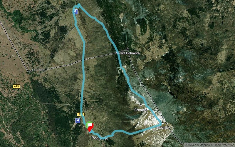


11.9 km
690 m
690 m
 Podgorje (SI)
 Points of Interest table
| Accum. | Intermediary | |||||||
|---|---|---|---|---|---|---|---|---|
| POI | Description | Alt. | Dist. | D+ | D- | Dist. | D+ | D- |
Trace n°66021
Ascent threshold : 1 m Distance threshold : 15 m Smoothing : Yes Origin of altitudes : MNT Aster GDEM
Ascent threshold : 1 m Distance threshold : 15 m Smoothing : Yes Origin of altitudes : MNT Aster GDEM
Loop
Dominant terrain : Footpath
Max alti. : 1013 m
Avg alti. : 689 m
Min alti. : 469 m
Longest ascent : 590 m
Longest descent : 530 m
Route completed by the author : Yes
Dominant terrain : Footpath
Max alti. : 1013 m
Avg alti. : 689 m
Min alti. : 469 m
Longest ascent : 590 m
Longest descent : 530 m
Route completed by the author : Yes
Elevation profile
More tools
Create a new roadbook page
Map and track on your website
Warning ! When you insert a Trace de Trail map on your website, you agree not to hide any element of the module (links to Trail Trail or Trail Connect banner)
Add a realisation
Validate
Add a realisation to share your chrono and describe the conditions that you encountered during you trail running !
Add a comment
Validate
Admin - Trace de Trail
18/08/18, 09:12:52
These rules have always been the same since the creation of the website
18/08/18, 09:12:52
These rules have always been the same since the creation of the website
Admin - Trace de Trail
18/08/18, 09:09:59
"Here are several rules to respect when naming your route correctly : Use geographical characters, for example summits, passes, villages through which your track passes."
18/08/18, 09:09:59
"Here are several rules to respect when naming your route correctly : Use geographical characters, for example summits, passes, villages through which your track passes."
More comments
sentierouno
18/08/18, 08:29:58
Where did you mention this in the site rules? When I subscribed to the site this was not stated in the rules and I did not get any notice of change of rules. You your be more professional and honest with the users. If I PAY FOR A SERVICE You cannot change the rules without notice or apply rules that are not stated in the public page. I will send a notice to ITRA
Admin - Trace de Trail
18/08/18, 08:26:17
If the track is not a competition, you can use only geographical names. If you want to provide further details, you can use the description field.
18/08/18, 08:26:17
If the track is not a competition, you can use only geographical names. If you want to provide further details, you can use the description field.
sentierouno
18/08/18, 08:18:59
The track is not a competition but Training for 2 distinct and separate competitions and it crosses some points of the 2 competitions. I must mention the name of the 2 competitions in the name of the track, as the users are looking for it for recognition. The training is a joint event of the 2 clubs organizing the 2 races. So the naming is correct. What you don't understand?
Admin - Trace de Trail
18/08/18, 08:12:19
If your track is a competition, you must classify it in competition, otherwise you must use the places crossed to name the track. What do not you understand?
18/08/18, 08:12:19
If your track is a competition, you must classify it in competition, otherwise you must use the places crossed to name the track. What do not you understand?
sentierouno
18/08/18, 08:08:42
Use geographical characters, for example summits, passes, villages through which your track passes. SLAVNIK Do not state the distance in the name of your track (this information is available elsewhere), except possibly to distinguish a competition route. NOT PRESENT Do not put information linked to the trip that you have made (length of the route, weather...) ; think however to add a realisation to your route ! NOT PRESENT Do not mention the starting area, it is already in your track's characteristics. NOT PRESENT For all competitions, state the year of the event in the name of the track. Use capital letters only for the first letter of your track's name and at the beginning of your own name. ACRONIMS
Admin - Trace de Trail
18/08/18, 08:01:21
Perfect ! But we must also read the following paragraph ... Thanks
18/08/18, 08:01:21
Perfect ! But we must also read the following paragraph ... Thanks
sentierouno
18/08/18, 07:53:34
Verify that the track that you wish to create does not already exist on Trace de Trail. VERIFIED Do not forget that Trace de Trail is 100% dedicated to trail-running… 100% TRAIL Do not be surprised if your track is renamed; we do this to guarantee a web-site which is both homogenous and of quality. NO PROBLEM You are a competition organiser : purchase a premium or premium+ subscription to add the “official route” label to your track. I DID
Admin - Trace de Trail
18/08/18, 07:15:49
Bonjour, Merci de respecter les règles de nommage du site avant de placer votre trace en public : https://tracedetrail.com/fr/accueil/help/alire
18/08/18, 07:15:49
Bonjour, Merci de respecter les règles de nommage du site avant de placer votre trace en public : https://tracedetrail.com/fr/accueil/help/alire
Show the infos
Add a track


