Show the map
Le Solberg - Petit Ballon - Le Steinberg - Stemlisberg
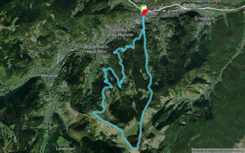


21.5 km
1360 m
1360 m
 Munster (68)
 Points of Interest table
| Accum. | Intermediary | |||||||
|---|---|---|---|---|---|---|---|---|
| POI | Description | Alt. | Dist. | D+ | D- | Dist. | D+ | D- |
Trace n°65534
Ascent threshold : 3 m Distance threshold : 30 m Smoothing : No Origin of altitudes : MNT Aster GDEM
Ascent threshold : 3 m Distance threshold : 30 m Smoothing : No Origin of altitudes : MNT Aster GDEM
Loop
Dominant terrain : Path
Max alti. : 1263 m
Avg alti. : 791 m
Min alti. : 379 m
Longest ascent : 920 m
Longest descent : 630 m
Route completed by the author : No
Dominant terrain : Path
Max alti. : 1263 m
Avg alti. : 791 m
Min alti. : 379 m
Longest ascent : 920 m
Longest descent : 630 m
Route completed by the author : No
Elevation profile
More tools
Create a new roadbook page
Map and track on your website
Warning ! When you insert a Trace de Trail map on your website, you agree not to hide any element of the module (links to Trail Trail or Trail Connect banner)
Add a realisation
Validate
Add a realisation to share your chrono and describe the conditions that you encountered during you trail running !
Add a comment
Validate
novass396
29/09/18, 20:25:24
J'ai essayé aujourd'hui : impossible a réaliser , passe sur des propriétés privés gardées par des chiens tres agressifs,ou a travers des zones verrouillées par des barbelés. Désolé ,mais j'ai perdu une heure a jardiner en espérant trouver un chemin praticable...j'ai fini par faire demi tour autour du premier bunker (km 1 )....dommage
Show the infos
Add a track


