Show the map
La Flégère - Tête aux Vents - Tré le Champ - Glacier d'Argentière - Le Chapeau
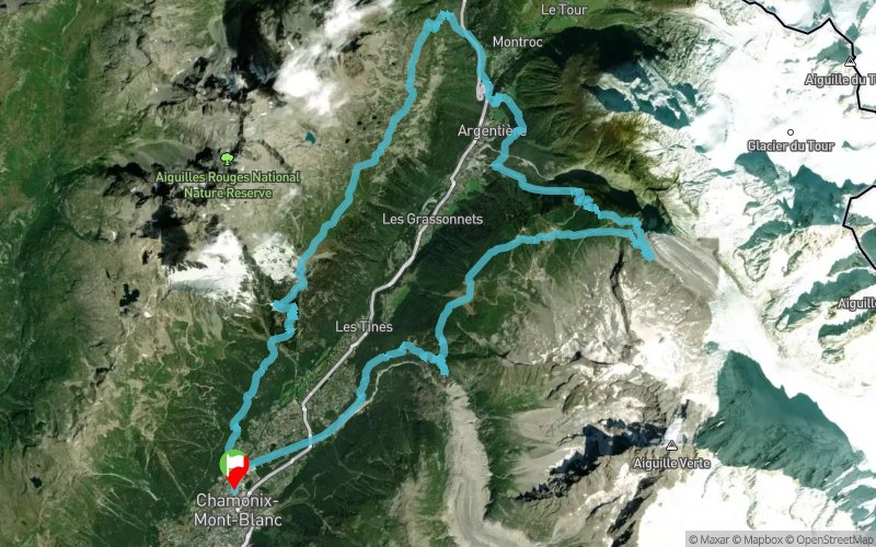


35.5 km
2590 m
2590 m
 Chamonix-Mont-Blanc (74)
 Points of Interest table
| Accum. | Intermediary | |||||||
|---|---|---|---|---|---|---|---|---|
| POI | Description | Alt. | Dist. | D+ | D- | Dist. | D+ | D- |
Trace n°61694
Ascent threshold : 3 m Distance threshold : 30 m Smoothing : Yes Origin of altitudes : MNT Aster GDEM
Ascent threshold : 3 m Distance threshold : 30 m Smoothing : Yes Origin of altitudes : MNT Aster GDEM
Loop
Dominant terrain : Footpath
Max alti. : 2353 m
Avg alti. : 1618 m
Min alti. : 1032 m
Longest ascent : 1230 m
Longest descent : 820 m
Route completed by the author : No
Dominant terrain : Footpath
Max alti. : 2353 m
Avg alti. : 1618 m
Min alti. : 1032 m
Longest ascent : 1230 m
Longest descent : 820 m
Route completed by the author : No
Elevation profile
More tools
Create a new roadbook page
Map and track on your website
Warning ! When you insert a Trace de Trail map on your website, you agree not to hide any element of the module (links to Trail Trail or Trail Connect banner)
Add a realisation
Validate
Add a realisation to share your chrono and describe the conditions that you encountered during you trail running !
Add a comment
Validate
cybneu
19/08/18, 16:55:24
Très belle boucle. La première partie de la montée depuis Argentieres est moins sympa car elle se fait sur une grosse piste en sable. Mais le reste est magnifique, que du petit sentier.
19/08/18, 16:55:24
Très belle boucle. La première partie de la montée depuis Argentieres est moins sympa car elle se fait sur une grosse piste en sable. Mais le reste est magnifique, que du petit sentier.
Show the infos
Add a track


