Show the map
Col du Brabant - Col de Bramont - Le Rainkopf
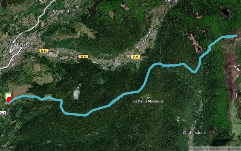


22.2 km
1031 m
1023 m
 La Bresse (88)
 Points of Interest table
| Accum. | Intermediary | |||||||
|---|---|---|---|---|---|---|---|---|
| POI | Description | Alt. | Dist. | D+ | D- | Dist. | D+ | D- |
Trace n°6069
Ascent threshold : 3 m Distance threshold : 30 m Smoothing : Yes Origin of altitudes : MNT Aster GDEM
Ascent threshold : 3 m Distance threshold : 30 m Smoothing : Yes Origin of altitudes : MNT Aster GDEM
Loop
Dominant terrain : Footpath
Max alti. : 1279 m
Avg alti. : 1048 m
Min alti. : 867 m
Longest ascent : 284 m
Longest descent : 270 m
Route completed by the author : nc
Dominant terrain : Footpath
Max alti. : 1279 m
Avg alti. : 1048 m
Min alti. : 867 m
Longest ascent : 284 m
Longest descent : 270 m
Route completed by the author : nc
Elevation profile
More tools
Create a new roadbook page
Map and track on your website
Warning ! When you insert a Trace de Trail map on your website, you agree not to hide any element of the module (links to Trail Trail or Trail Connect banner)
Add a realisation
Validate
Add a realisation to share your chrono and describe the conditions that you encountered during you trail running !
Add a comment
Validate
bertrandguillaume
09/02/15, 18:47:25
Sortie faite le 13/03/14. Pas de neige au départ....bonne couche de neige au Rainkopf !
09/02/15, 18:47:25
Sortie faite le 13/03/14. Pas de neige au départ....bonne couche de neige au Rainkopf !
Show the infos
Add a track


