Show the map
OFFICIAL ROUTE
La Découverte du Graoully 2018
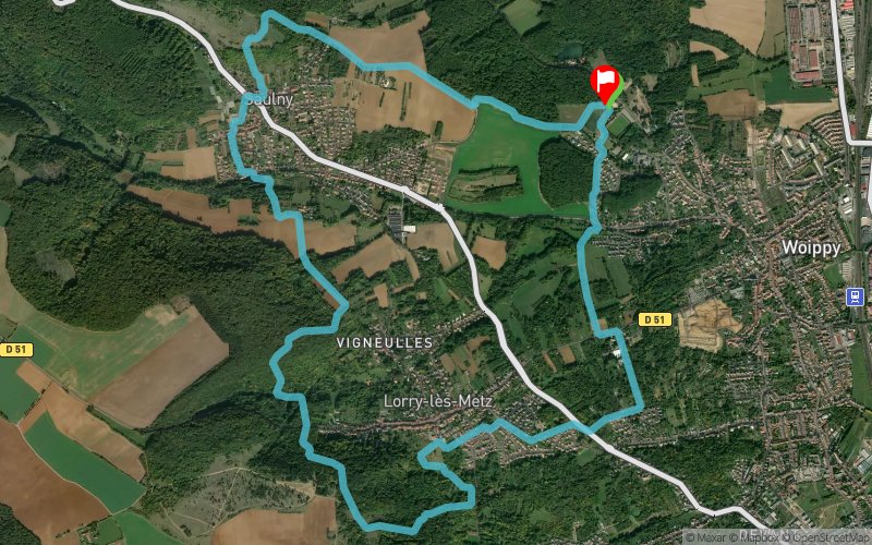


12 km
400 m
400 m
 Woippy (57)
 Woippy (57)
 Points of Interest table
| Accum. | Intermediary | |||||||
|---|---|---|---|---|---|---|---|---|
| POI | Description | Alt. | Dist. | D+ | D- | Dist. | D+ | D- |
 Competition organized on 04/07/2018
Trace n°56109
Ascent threshold : 3 m Distance threshold : 0 m Smoothing : No Origin of altitudes : GPS
Ascent threshold : 3 m Distance threshold : 0 m Smoothing : No Origin of altitudes : GPS
Loop
Dominant terrain : Footpath
Max alti. : 341 m
Avg alti. : 263 m
Min alti. : 183 m
Longest ascent : 130 m
Longest descent : 150 m
Dominant terrain : Footpath
Max alti. : 341 m
Avg alti. : 263 m
Min alti. : 183 m
Longest ascent : 130 m
Longest descent : 150 m
Elevation profile
More tools
Create a new roadbook page
Map and track on your website
Warning ! When you insert a Trace de Trail map on your website, you agree not to hide any element of the module (links to Trail Trail or Trail Connect banner)
Add a realisation
Validate
Add a realisation to share your chrono and describe the conditions that you encountered during you trail running !
Add a comment
Validate
FranckDu74
10/04/18, 09:44:19
Parti avec le dossard 1202 je boucle ce 12kms découverte en 1h 23min 32s à la 59ième place Mon premier trail
10/04/18, 09:44:19
Parti avec le dossard 1202 je boucle ce 12kms découverte en 1h 23min 32s à la 59ième place Mon premier trail
Show the infos
Add a track


