Show the map
Certified Track - ITRA
Valmalenco Ultradistance Trail 2018
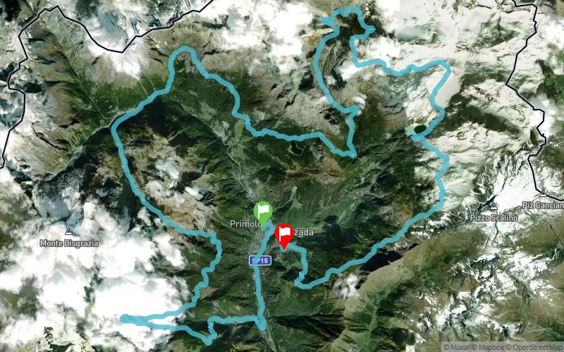


88.9 km
5770 m
5630 m
 Chiesa In Valmalenco (IT)
 Caspoggio (IT)
 9
9 390
390 Points of Interest table
| Accum. | Intermediary | |||||||
|---|---|---|---|---|---|---|---|---|
| POI | Description | Alt. | Dist. | D+ | D- | Dist. | D+ | D- |
 Competition organized on 07/21/2018
Trace n°50545
Ascent threshold : 3 m Distance threshold : 0 m Smoothing : No Origin of altitudes : GPS
Ascent threshold : 3 m Distance threshold : 0 m Smoothing : No Origin of altitudes : GPS
Crossing
Dominant terrain : Footpath
Max alti. : 2668 m
Avg alti. : 1894 m
Min alti. : 701 m
Longest ascent : 1340 m
Longest descent : 1060 m
Dominant terrain : Footpath
Max alti. : 2668 m
Avg alti. : 1894 m
Min alti. : 701 m
Longest ascent : 1340 m
Longest descent : 1060 m
Elevation profile
More tools
Create a new roadbook page
Map and track on your website
Warning ! When you insert a Trace de Trail map on your website, you agree not to hide any element of the module (links to Trail Trail or Trail Connect banner)
Add a realisation
Validate
Add a realisation to share your chrono and describe the conditions that you encountered during you trail running !
Add a comment
Validate
Admin - Trace de Trail
30/12/19, 22:49:44
Bonjour, Merci de créer une nouvelle trace pour l'édition 2019 de votre compétition.
30/12/19, 22:49:44
Bonjour, Merci de créer une nouvelle trace pour l'édition 2019 de votre compétition.
Show the infos
Add a track


