Show the map
La Bihorée - Oratoire Ste-Anne - La Cour Suzanne
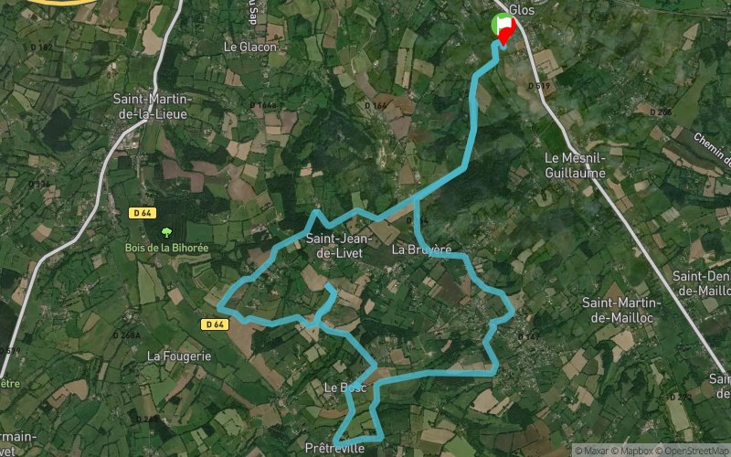


19.3 km
442 m
442 m
 Glos (14)
 Points of Interest table
| Accum. | Intermediary | |||||||
|---|---|---|---|---|---|---|---|---|
| POI | Description | Alt. | Dist. | D+ | D- | Dist. | D+ | D- |
Trace n°4939
Ascent threshold : 0 m Distance threshold : 35 m Smoothing : Yes Origin of altitudes : MNT Aster GDEM
Ascent threshold : 0 m Distance threshold : 35 m Smoothing : Yes Origin of altitudes : MNT Aster GDEM
Loop
Dominant terrain : Footpath
Max alti. : 176 m
Avg alti. : 131 m
Min alti. : 48 m
Longest ascent : 171 m
Longest descent : 125 m
Route completed by the author : nc
Dominant terrain : Footpath
Max alti. : 176 m
Avg alti. : 131 m
Min alti. : 48 m
Longest ascent : 171 m
Longest descent : 125 m
Route completed by the author : nc
Elevation profile
More tools
Create a new roadbook page
Map and track on your website
Warning ! When you insert a Trace de Trail map on your website, you agree not to hide any element of the module (links to Trail Trail or Trail Connect banner)
Add a realisation
Validate
Add a realisation to share your chrono and describe the conditions that you encountered during you trail running !
Add a comment
Validate
Admin - Trace de Trail
09/11/14, 09:35:54
Bonjour,
09/11/14, 09:35:54
Bonjour,
Merci pour ce commentaire très utile !
Par contre, il serait mieux placé dans la description de la trace... 
cricrilapancarte
09/11/14, 09:18:38
Belle balade dans la nature augerone. Parcours assez facile, à l'exception de quelques passages en monotrace un peu technique.

09/11/14, 09:18:38
Belle balade dans la nature augerone. Parcours assez facile, à l'exception de quelques passages en monotrace un peu technique.
A noter le passage auprès d'une véritable cascade après Pretreville, repérable facilement à l'oreille, mais pour laquelle il faut s'écarter du chemin pour la contempler.
Circuit réalisable de nuit avec une frontale sans difficulté.
Show the infos
Add a track


