Show the map
Ultra Titicaca Trail 2017 - 60K


 Inconnu (PE)
 Inconnu (PE)
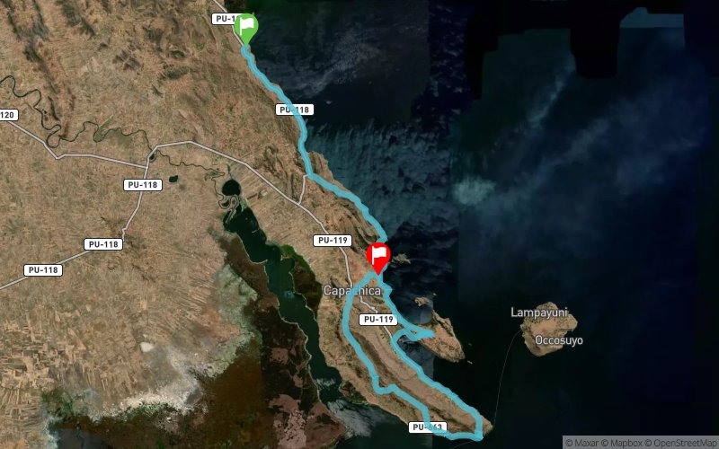
The ULTRA TITICACA TRAIL UTT 2017 is an Ultramarathon race or mountain race), Non Stop mode, with a cold and sunny climate, with probability of rain, with temperatures reaching 2 degrees at night and 17 degrees day in the Peruvian Altiplano zone, following a route route, along the roads around Lake Titicaca, in the Peninsula area of ??Capachica, Department of Puno, Republic of Peru.
Points of Interest table
| Accum. | Intermediary | |||||||
|---|---|---|---|---|---|---|---|---|
| POI | Description | Alt. | Dist. | D+ | D- | Dist. | D+ | D- |
 Competition organized on 11/05/2017
Trace n°44882
Ascent threshold : 3 m Distance threshold : 30 m Smoothing : Yes Origin of altitudes : MNT Google
Ascent threshold : 3 m Distance threshold : 30 m Smoothing : Yes Origin of altitudes : MNT Google
Crossing
Dominant terrain : Footpath
Max alti. : 4046 m
Avg alti. : 3881 m
Min alti. : 3818 m
Longest ascent : 220 m
Longest descent : 230 m
Dominant terrain : Footpath
Max alti. : 4046 m
Avg alti. : 3881 m
Min alti. : 3818 m
Longest ascent : 220 m
Longest descent : 230 m
Elevation profile
More tools
Create a new roadbook page
Map and track on your website
Warning ! When you insert a Trace de Trail map on your website, you agree not to hide any element of the module (links to Trail Trail or Trail Connect banner)
Add a realisation
Validate
Add a realisation to share your chrono and describe the conditions that you encountered during you trail running !
Add a comment
Validate
Show the infos
Add a track


