Show the map
Barragem do Sabugal - Malcata
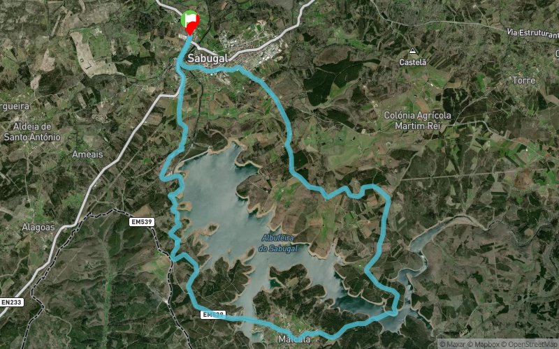


21.8 km
400 m
400 m
 Sabugal (PT)
 Points of Interest table
| Accum. | Intermediary | |||||||
|---|---|---|---|---|---|---|---|---|
| POI | Description | Alt. | Dist. | D+ | D- | Dist. | D+ | D- |
Trace n°44652
Ascent threshold : 3 m Distance threshold : 30 m Smoothing : Yes Origin of altitudes : MNT Aster GDEM
Ascent threshold : 3 m Distance threshold : 30 m Smoothing : Yes Origin of altitudes : MNT Aster GDEM
Loop
Dominant terrain : Path
Max alti. : 867 m
Avg alti. : 803 m
Min alti. : 732 m
Longest ascent : 100 m
Longest descent : 120 m
Route completed by the author : nc
Dominant terrain : Path
Max alti. : 867 m
Avg alti. : 803 m
Min alti. : 732 m
Longest ascent : 100 m
Longest descent : 120 m
Route completed by the author : nc
Elevation profile
More tools
Create a new roadbook page
Map and track on your website
Warning ! When you insert a Trace de Trail map on your website, you agree not to hide any element of the module (links to Trail Trail or Trail Connect banner)
Add a realisation
Validate
Add a realisation to share your chrono and describe the conditions that you encountered during you trail running !
Add a comment
Validate
JM_73
26/09/17, 12:21:35
between Km8 and Km10, there is a bridge. between km10 and km12, you have to swim .... so take your waterproof bag for the shoes (and other) and attach it with a rope to your body ... that is good fun !!
26/09/17, 12:21:35
between Km8 and Km10, there is a bridge. between km10 and km12, you have to swim .... so take your waterproof bag for the shoes (and other) and attach it with a rope to your body ... that is good fun !!
Show the infos
Add a track


