Show the map
Certified Track - ITRA
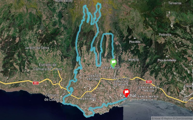
Ecotrail Funchal Madeira Compressport 2017 - 40 km


 Candelária (PT)
 Funchal (PT)


The start of this race will be at 7:30 a.m. in the morning of the 28 of October, at the Meeting Point, at Alegria, in S. Roque. The athletes are faced with a brutal uphill that will requires all their strength and energy, but soon after, they start their swift descent as far as Ribeira Grande in Santo António. At Levada Negra they are faced with the next harsh slope that they have to overcome, before they reach Terreiro do Freixo, and from there they have to go, more gently, up and downhill as far as Pico do Buxo. Ahead of them, now, emerges another downhill path always with breathtaking views over Funchal. From Estrela to the coastal area, the run continues through trails and paths, while experiencing the essence of the hidden corners of the city. Towards the end, it is a stroll along the coastal area, passing briefly along Levada dos Piornais and a triumphant descent to Avenida do Infante to the finish line at Avenida Arriaga.
Points of Interest table
| Accum. | Intermediary | |||||||
|---|---|---|---|---|---|---|---|---|
| POI | Description | Alt. | Dist. | D+ | D- | Dist. | D+ | D- |
 Competition organized on 10/28/2017
Trace n°42347
Ascent threshold : 10 m Distance threshold : 0 m Smoothing : No Origin of altitudes : GPS
Ascent threshold : 10 m Distance threshold : 0 m Smoothing : No Origin of altitudes : GPS
Crossing
Dominant terrain : Footpath
Max alti. : 1499 m
Avg alti. : 789 m
Min alti. : 7 m
Longest ascent : 1430 m
Longest descent : 1810 m
Dominant terrain : Footpath
Max alti. : 1499 m
Avg alti. : 789 m
Min alti. : 7 m
Longest ascent : 1430 m
Longest descent : 1810 m
Elevation profile
More tools
Create a new roadbook page
Map and track on your website
Warning ! When you insert a Trace de Trail map on your website, you agree not to hide any element of the module (links to Trail Trail or Trail Connect banner)
Add a realisation
Validate
Add a realisation to share your chrono and describe the conditions that you encountered during you trail running !
Add a comment
Validate
Show the infos
Add a track


