Show the map
La Cude - Mont Afrique - La Toppe - Roche Pompon - Roche d'Anse
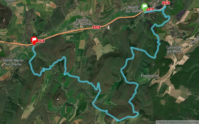


33.3 km
1780 m
1760 m
 Velars-sur-Ouche (21)
 Sainte-Marie-sur-Ouche (21)
 Points of Interest table
| Accum. | Intermediary | |||||||
|---|---|---|---|---|---|---|---|---|
| POI | Description | Alt. | Dist. | D+ | D- | Dist. | D+ | D- |
Trace n°42294
Ascent threshold : 3 m Distance threshold : 30 m Smoothing : Yes Origin of altitudes : MNT Aster GDEM
Ascent threshold : 3 m Distance threshold : 30 m Smoothing : Yes Origin of altitudes : MNT Aster GDEM
Crossing
Dominant terrain : Footpath
Max alti. : 591 m
Avg alti. : 435 m
Min alti. : 260 m
Longest ascent : 280 m
Longest descent : 270 m
Route completed by the author : Yes
Dominant terrain : Footpath
Max alti. : 591 m
Avg alti. : 435 m
Min alti. : 260 m
Longest ascent : 280 m
Longest descent : 270 m
Route completed by the author : Yes
Elevation profile
More tools
Create a new roadbook page
Map and track on your website
Warning ! When you insert a Trace de Trail map on your website, you agree not to hide any element of the module (links to Trail Trail or Trail Connect banner)
Add a realisation
Validate
Add a realisation to share your chrono and describe the conditions that you encountered during you trail running !
Add a comment
Validate
More comments
Bubu467
26/03/18, 16:56:33
J'ai indiqué le nom du sentier balisé, Je n'ai pas compris ce que je dois mettre à la place. Pouvez vous m'aider svp?
26/03/18, 16:56:33
J'ai indiqué le nom du sentier balisé, Je n'ai pas compris ce que je dois mettre à la place. Pouvez vous m'aider svp?
Admin - Trace de Trail
25/03/18, 23:14:41
Bonjour, Merci de respecter les règles de nommage du site avant de placer votre trace en publique : https://tracedetrail.fr/fr/accueil/help/alire
25/03/18, 23:14:41
Bonjour, Merci de respecter les règles de nommage du site avant de placer votre trace en publique : https://tracedetrail.fr/fr/accueil/help/alire
Show the infos
Add a track


