Show the map
Chrysa Trail 2017
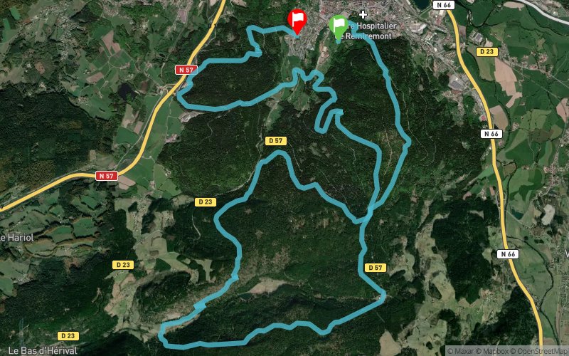


26 km
1240 m
1190 m
 Remiremont (88)
 Remiremont (88)
 Points of Interest table
| Accum. | Intermediary | |||||||
|---|---|---|---|---|---|---|---|---|
| POI | Description | Alt. | Dist. | D+ | D- | Dist. | D+ | D- |
 Competition organized on 03/05/2017
Trace n°33930
Ascent threshold : 3 m Distance threshold : 30 m Smoothing : Yes Origin of altitudes : MNT Aster GDEM
Ascent threshold : 3 m Distance threshold : 30 m Smoothing : Yes Origin of altitudes : MNT Aster GDEM
Loop
Dominant terrain : Footpath
Max alti. : 740 m
Avg alti. : 626 m
Min alti. : 417 m
Longest ascent : 300 m
Longest descent : 250 m
Dominant terrain : Footpath
Max alti. : 740 m
Avg alti. : 626 m
Min alti. : 417 m
Longest ascent : 300 m
Longest descent : 250 m
Elevation profile
More tools
Create a new roadbook page
Map and track on your website
Warning ! When you insert a Trace de Trail map on your website, you agree not to hide any element of the module (links to Trail Trail or Trail Connect banner)
Add a realisation
Validate
Add a realisation to share your chrono and describe the conditions that you encountered during you trail running !
Add a comment
Validate
nacerup
24/07/18, 20:34:21
Super trace, Parcours forestier....les Vosges en brut de brut Même si le dénivelé n est pas si important, ça permet de courir dans les montées Je le conseil complètement
24/07/18, 20:34:21
Super trace, Parcours forestier....les Vosges en brut de brut Même si le dénivelé n est pas si important, ça permet de courir dans les montées Je le conseil complètement
Show the infos
Add a track


