Circuit 25 red - Loop of La Pointe de Bellevue
Add to my favorites

Be careful on the trail course, the trailer is AUTONOMOUS
Route closed

A difficult path but a one you're going to be amazed with.
The characteristics of the route.
Morgins (CH)
- Distance 16 km
- Elevation gain 911 m
- Elevation lost 902 m
- Min. elevation 1310 m
- Max. elevation. 2028 m
- Duration (depending on pace) 3h
- Marking yes
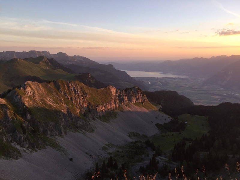
The first part starting from the tourism office in Morgins is on the road to reach beautiful paths, running into forests, rivers and pastures. If you wish to stop and have a break on the way up, the Ferrage and Champost pasture restaurant will warmly welcome you. Don't hesitate to slow down your speed while running up, and walk on the last part. This last part of the ascent propose an important difference in heigh, on pure tradition of trail running. Your effort will be granted at your arrival at the Pointe de Bellevue, one of the most beautiful spot on the Portes du Soleil area. The 360° view shows the Leman lake, the swiss Chablais, high Valais montain, the Dents du Midi, the Dents blanches, The Mont Blanc... After a picture break, you may start to run down. First descent is on technical trail paths until Portes de Culet. At that point, if you wish to do a longer run you can continue on the 'Tour du bec du Corbeau" in Châtel. After 11,5km, you will run on a road for 2km before reaching the Morgins Lake. The last part continues around the lake through beautifull forests, and eventually arrive at the center of the village.
Area : Val d'Illiez - Suisse
Report a problem 1 comment
PDF map fabrunner1
finished in 02:10:00
The 2017/08/22
En savoir plus
Ajouter votre chrono et partager vos sensations
2017/08/22 02:10:00
fabrunner1
fabrunner1
2017/08/22 02:10:00
fabrunner1
fabrunner1


Follow us on
the digital trails
the digital trails


![]()
Info & contacts
Portes du Soleil Association
1401, route de Vonnes
74390 Châtel FRANCE
+33(0)4.50.73.32.54
info@portesdusoleil.com


OK
Annuler