Show the map
Rocher du Corbeau - Weissenberg
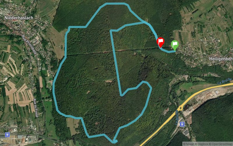


10 km
341 m
375 m
 Heiligenberg (67)
 Heiligenberg (67)
 Points of Interest table
| Accum. | Intermediary | |||||||
|---|---|---|---|---|---|---|---|---|
| POI | Description | Alt. | Dist. | D+ | D- | Dist. | D+ | D- |
Trace n°25796
Ascent threshold : 2 m Distance threshold : 30 m Smoothing : Yes Origin of altitudes : MNT Aster GDEM
Ascent threshold : 2 m Distance threshold : 30 m Smoothing : Yes Origin of altitudes : MNT Aster GDEM
Loop
Dominant terrain : Path
Max alti. : 410 m
Avg alti. : 307 m
Min alti. : 237 m
Longest ascent : 160 m
Longest descent : 120 m
Route completed by the author : nc
Dominant terrain : Path
Max alti. : 410 m
Avg alti. : 307 m
Min alti. : 237 m
Longest ascent : 160 m
Longest descent : 120 m
Route completed by the author : nc
Elevation profile
More tools
Create a new roadbook page
Map and track on your website
Warning ! When you insert a Trace de Trail map on your website, you agree not to hide any element of the module (links to Trail Trail or Trail Connect banner)
Add a realisation
Validate
Add a realisation to share your chrono and describe the conditions that you encountered during you trail running !
Add a comment
Validate
Yann67
04/11/16, 13:42:59
Surprenant car c'est un tracé importé de mon GPS et non tracé sur carte, je le teste des que possible afin de rectifier cela.
04/11/16, 13:42:59
Surprenant car c'est un tracé importé de mon GPS et non tracé sur carte, je le teste des que possible afin de rectifier cela.
DomLadyGym
01/11/16, 17:49:34
Trace difficile à suivre sur la partie basse (près du rocher) . Le GPS nous a fait sortir du tracé et nous nous sommes perdues ! Retour par Heilligenberg village.. !
01/11/16, 17:49:34
Trace difficile à suivre sur la partie basse (près du rocher) . Le GPS nous a fait sortir du tracé et nous nous sommes perdues ! Retour par Heilligenberg village.. !
Show the infos
Add a track


