Show the map
Certified Track - ITRA
Grand Raid 3V Remix 2016


 Bione (IT)


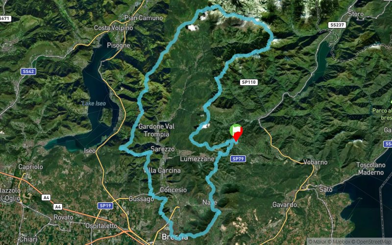
The Grand Raid 3v Remix is an event that has a length of 165 km with approximately 8700 m of elevation gain .
Retraces the " 3 V " or " Path of the Three Valleys - Silvano Cinelli . " It is a unique hiking route for many reasons , among them , its structure , its history and its management .
And ' structured on a medium / low altitude route starting and finishing in Bione , with development along the entire ridge of the watershed Trompia valley with the neighboring valleys : Valley Sand ( and tax Caffaro valley ) to the east and north ; low Camonica and Sebino west valley.
A big circle, therefore, that embraces the three valleys Brescia linking closely to the capital ; a multiple combination full of meanings!
Points of Interest table
| Accum. | Intermediary | |||||||
|---|---|---|---|---|---|---|---|---|
| POI | Description | Alt. | Dist. | D+ | D- | Dist. | D+ | D- |
 Competition organized on 08/05/2016
Trace n°22143
Ascent threshold : 3 m Distance threshold : 0 m Smoothing : No Origin of altitudes : GPS + MNT Aster GDEM
Ascent threshold : 3 m Distance threshold : 0 m Smoothing : No Origin of altitudes : GPS + MNT Aster GDEM
Loop
Dominant terrain : Footpath
Max alti. : 2087 m
Avg alti. : 1087 m
Min alti. : 141 m
Longest ascent : 1060 m
Longest descent : 910 m
Dominant terrain : Footpath
Max alti. : 2087 m
Avg alti. : 1087 m
Min alti. : 141 m
Longest ascent : 1060 m
Longest descent : 910 m
Elevation profile
More tools
Create a new roadbook page
Map and track on your website
Warning ! When you insert a Trace de Trail map on your website, you agree not to hide any element of the module (links to Trail Trail or Trail Connect banner)
Add a realisation
Validate
Add a realisation to share your chrono and describe the conditions that you encountered during you trail running !
Add a comment
Validate
Show the infos
Add a track


