Show the map
Les Alouettes - Affringues - St-Pierre - Bois du Fays
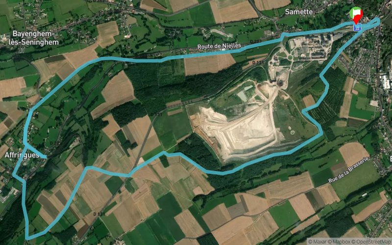


11.1 km
200 m
200 m
 Lumbres (62)
 Points of Interest table
| Accum. | Intermediary | |||||||
|---|---|---|---|---|---|---|---|---|
| POI | Description | Alt. | Dist. | D+ | D- | Dist. | D+ | D- |
Trace n°20383
Ascent threshold : 3 m Distance threshold : 30 m Smoothing : Yes Origin of altitudes : MNT Aster GDEM
Ascent threshold : 3 m Distance threshold : 30 m Smoothing : Yes Origin of altitudes : MNT Aster GDEM
Loop
Dominant terrain : Footpath
Max alti. : 147 m
Avg alti. : 76 m
Min alti. : 42 m
Longest ascent : 100 m
Longest descent : 80 m
Route completed by the author : nc
Dominant terrain : Footpath
Max alti. : 147 m
Avg alti. : 76 m
Min alti. : 42 m
Longest ascent : 100 m
Longest descent : 80 m
Route completed by the author : nc
Elevation profile
More tools
Create a new roadbook page
Map and track on your website
Warning ! When you insert a Trace de Trail map on your website, you agree not to hide any element of the module (links to Trail Trail or Trail Connect banner)
Add a realisation
Validate
Add a realisation to share your chrono and describe the conditions that you encountered during you trail running !
Add a comment
Validate
papaTangoCharlie
19/04/17, 18:58:58
hello ça ressemble au parcours 6 de la station de train il me semble. sympa et roulant pour les coureurs rapide. la côte de mi parcours fait mal...très mal... par contre le tour ne fait que 10km
19/04/17, 18:58:58
hello ça ressemble au parcours 6 de la station de train il me semble. sympa et roulant pour les coureurs rapide. la côte de mi parcours fait mal...très mal... par contre le tour ne fait que 10km
Show the infos
Add a track


