Show the map
transgrancanaria 2014
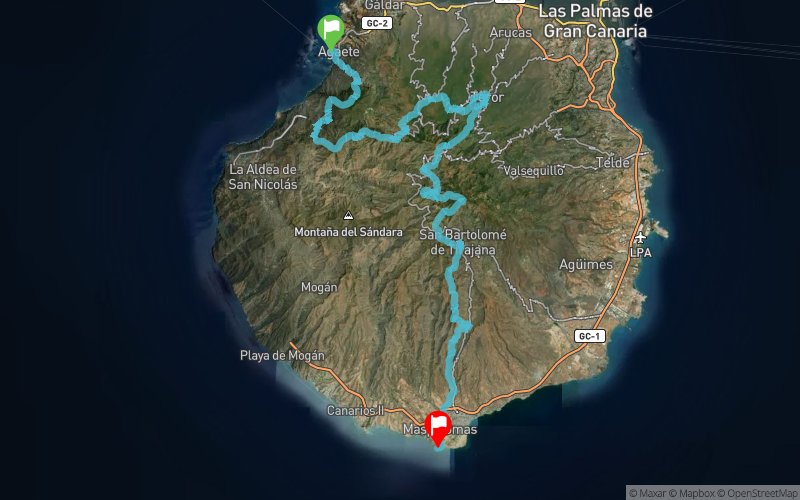


 Puerto De Las Nieves (ES)
 Meloneras, Las (ES)
 Points of Interest table
| Accum. | Intermediary | |||||||
|---|---|---|---|---|---|---|---|---|
| POI | Description | Alt. | Dist. | D+ | D- | Dist. | D+ | D- |
 Competition organized on 03/01/2014
Trace n°2019
Ascent threshold : 0 m Distance threshold : 0 m Smoothing : No Origin of altitudes : MNT Aster GDEM
Ascent threshold : 0 m Distance threshold : 0 m Smoothing : No Origin of altitudes : MNT Aster GDEM
Crossing
Dominant terrain : Footpath
Max alti. : 1931 m
Avg alti. : 946 m
Min alti. : 1 m
Longest ascent : 1294 m
Longest descent : 1024 m
Dominant terrain : Footpath
Max alti. : 1931 m
Avg alti. : 946 m
Min alti. : 1 m
Longest ascent : 1294 m
Longest descent : 1024 m
Elevation profile
More tools
Create a new roadbook page
Map and track on your website
Warning ! When you insert a Trace de Trail map on your website, you agree not to hide any element of the module (links to Trail Trail or Trail Connect banner)
Add a realisation
Validate
Add a realisation to share your chrono and describe the conditions that you encountered during you trail running !
Add a comment
Validate
Admin - Trace de Trail
08/03/14, 17:42:15
Salut Joël,
Lorsque tu importes le gpx en mode expert, as-tu essayé de mette la valeur de ré-échantillonnage sur 0 ?
08/03/14, 17:42:15
Salut Joël,
Lorsque tu importes le gpx en mode expert, as-tu essayé de mette la valeur de ré-échantillonnage sur 0 ?
joel38
08/03/14, 13:58:24
Normalement la course est donné pour 125 km et 8200 D+ je pense que la différence est due a l'enregistrement qui a était fait en mode 50 h sur Suunto ambit 2 .
08/03/14, 13:58:24
Normalement la course est donné pour 125 km et 8200 D+ je pense que la différence est due a l'enregistrement qui a était fait en mode 50 h sur Suunto ambit 2 .
Course magnifique avec des paysages a couper le souffle !!!
Show the infos
Add a track


