Show the map
Parcours 15 km dans Paris
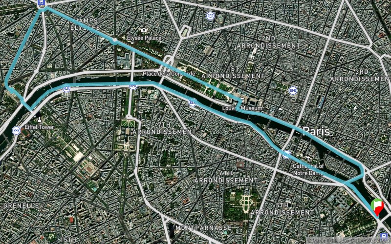


14.6 km
139 m
139 m
 Paris 05 (75)
 Points of Interest table
| Accum. | Intermediary | |||||||
|---|---|---|---|---|---|---|---|---|
| POI | Description | Alt. | Dist. | D+ | D- | Dist. | D+ | D- |
Trace n°1616
Ascent threshold : 0 m Distance threshold : 35 m Smoothing : Yes Origin of altitudes : MNT Aster GDEM
Ascent threshold : 0 m Distance threshold : 35 m Smoothing : Yes Origin of altitudes : MNT Aster GDEM
Loop
Dominant terrain : Road
Max alti. : 75 m
Avg alti. : 32 m
Min alti. : 17 m
Longest ascent : 60 m
Longest descent : 52 m
Route completed by the author : nc
Dominant terrain : Road
Max alti. : 75 m
Avg alti. : 32 m
Min alti. : 17 m
Longest ascent : 60 m
Longest descent : 52 m
Route completed by the author : nc
Elevation profile
More tools
Create a new roadbook page
Map and track on your website
Warning ! When you insert a Trace de Trail map on your website, you agree not to hide any element of the module (links to Trail Trail or Trail Connect banner)
Add a realisation
Validate
Add a realisation to share your chrono and describe the conditions that you encountered during you trail running !
Add a comment
Validate
Admin - Trace de Trail
11/01/14, 18:18:35
Bonjour,
J'ai modifié le terrain dominant de "sentier" à "route"... Je ne pense pas trop me tromper
11/01/14, 18:18:35
Bonjour,
J'ai modifié le terrain dominant de "sentier" à "route"... Je ne pense pas trop me tromper
Show the infos
Add a track


