Thyez and its interpretation trail - Hike
Add to my favorites

Route opened
The Pointe d'Orchex offers you a superb panorama over the Arve valley, the Môle and the Bargy Massif. Designed for young and old, this fun and educational route is offered to you to understand the characteristic environment of the territory.
The characteristics of the route.

Thyez (74)
- Distance 5.6 km
- Elevation gain 340 m
- Elevation lost 340 m
- Min. elevation 674 m
- Max. elevation. 1004 m
- Duration (depending on pace) 2h
- Marking Yes
From Rontalon Parking to Sur le Coux: 40 minutes
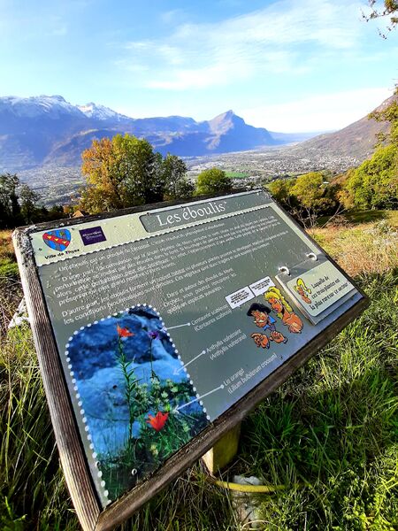
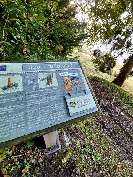
Follow the tarmac road for 200 meters to the hamlet of Rontalon. The path begins on the left in the pastures. The path continues, marked with 8 explanatory panels on fauna, flora and forest to join the tarmac road. Follow the signs. You reach the asphalt road again, until Sur le Coux.
From Sur le Coux to Le Coux de Marignier: 20 minutes
Take the road suitable for vehicles, to the right of the Auberge de la Pointe d'Orchex to Coux de Marignier.
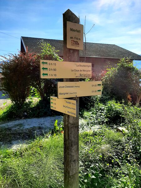
From Coux de Marignier to Nierfait: 35 minutes
Descend by the path that plunges into the forest. Follow the signs to Bourbonnyre and Nierfait.
From Nierfait to Rontalon Parking: 25 minutes
At a place called Nierfait, take the road on the left, and pass a bus stop
Nierfait. Continue straight on the road until the next markup. The path
go down a little on the right, and go up a little further. At road level,
continue right until the bus stop "la Riolle". Cross and climb the Riolle road and follow the signs to reach the starting point.Marking : The trail is marked with signs.Admission fee : Free access. Detailed sheet available at the Tourist Office.Opening : From 01/04 to 15/11. Subject to favorable weather.
Follow the tarmac road for 200 meters to the hamlet of Rontalon. The path begins on the left in the pastures. The path continues, marked with 8 explanatory panels on fauna, flora and forest to join the tarmac road. Follow the signs. You reach the asphalt road again, until Sur le Coux.
From Sur le Coux to Le Coux de Marignier: 20 minutes
Take the road suitable for vehicles, to the right of the Auberge de la Pointe d'Orchex to Coux de Marignier.
From Coux de Marignier to Nierfait: 35 minutes
Descend by the path that plunges into the forest. Follow the signs to Bourbonnyre and Nierfait.
From Nierfait to Rontalon Parking: 25 minutes
At a place called Nierfait, take the road on the left, and pass a bus stop
Nierfait. Continue straight on the road until the next markup. The path
go down a little on the right, and go up a little further. At road level,
continue right until the bus stop "la Riolle". Cross and climb the Riolle road and follow the signs to reach the starting point.Marking : The trail is marked with signs.Admission fee : Free access. Detailed sheet available at the Tourist Office.Opening : From 01/04 to 15/11. Subject to favorable weather.
Area : Cluses Arve & Montagnes
Report a problem Add a comment
PDF map
Add your time and share your feelings


Information updated on 2022-08-27 by Cluses Arve & montagnes Tourisme


Follow us on
the digital trails
the digital trails


![]()
Infos & contacts
Flaine Tourist Office
Tél. +33 (0)4 50 90 80 01
Les Carroz sports club
sports@aracheslafrasse.fr - Tél. +33 (0)4 50 90 24 80
Cluses Arve & montagnes Tourist Office
Tél. +33 (0)4 50 96 69 69


OK
Annuler