Vaujany and Col du Sabot
Add to my favorites

Caution! Zone of vigilance near the route
Faucon pèlerin - du 01/02/2024 au 30/06/2024 In progress
Circaète Jean-le-Blanc - du 01/03/2024 au 30/09/2024 In progress
Circaète Jean-le-Blanc - du 01/03/2024 au 30/09/2024 In progress
Aigle royal - du 01/01/2024 au 31/08/2024 In progress
Aigle royal - du 01/01/2024 au 31/08/2024 In progress

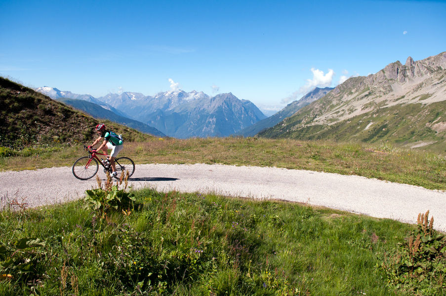
The small and narrow road to Col du Sabot threads through the alpine pastures of Vaujany. The climb is strenuous. Here, it is not unusual to come across a few cows! At the end of the ride, you will be rewarded with a view over the Lake Grand Maison.
The characteristics of the route.

Le Bourg-d'Oisans (38)
- Distance 57.8 km
- Elevation gain 1500 m
- Elevation lost 1500 m
- Min. elevation 708 m
- Max. elevation. 2098 m
- Duration (depending on pace) 2h30
- Marking No
Itinerary no. 12 of the “Cycling in Oisans” guide (Oisans Tourisme)
Departure / Arrival: Bourg d’Oisans 720 m
Time: 2 h 30
Distance (R/T): 57 km
Highest point: 2100 m
Lowest point: 710 m
Total ascent: 1565 m
Max. gradient: 12%
Map: Michelin Local Map no. 333 Isère, Savoie
ITINERARY
From Bourg d’Oisans, follow the D1091 towards Grenoble.
In Rochetaillée, take the direction of “Allemond / Vaujany”.
After Allemond, climb up 2 hairpin bends to get to the top of the Verney dam. At the end of the dam, follow the route along the shore of Lake Verney towards Vaujany.
At the end of the lake, turn right and start climbing up to the Col du Sabot. You will pass through 4 hamlets before arriving at Vaujany.
Once in Vaujany, cycle towards “Vaujany - Village”. Cross the village in the direction of La Villette / le Collet.
At Collet, keep following the road, from here you have 7 km climb up to Col du Sabot (2100 m).
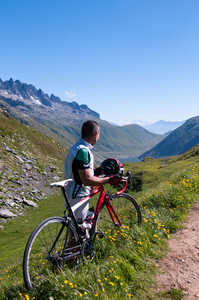
THAT LITTLE BIT FURTHER: Les cheminées d’équilibre
You can add the climb up the “Cheminées d’équilibre” as you enter Vaujany.
It is a pastoral although rather strenuous itinerary offering a charming view over a lovely sunny mountainside facing the glaciers of the Grandes Rousses massif and the waterfalls of La Fare.
---
Distance (R/T): 10 km
Time: 1 h
Total ascent: 510 m
HISTORY
For centuries, the Col du Sabot was the gateway to cross the border between France and Savoy. The word “Sabot” comes from “Sabaudia” which means Savoy in the dialect. This border and its customs disappeared in 1850 with the annexation of Savoy to France. With the development of the road network and the democratization of cars, this route was gradually abandoned in favour of the current road that joins Col du Glandon and Col de la Croix de Fer by Rivier d'Allemond.Opening : From 01/06 to 15/11.
Departure / Arrival: Bourg d’Oisans 720 m
Time: 2 h 30
Distance (R/T): 57 km
Highest point: 2100 m
Lowest point: 710 m
Total ascent: 1565 m
Max. gradient: 12%
Map: Michelin Local Map no. 333 Isère, Savoie
ITINERARY
From Bourg d’Oisans, follow the D1091 towards Grenoble.
In Rochetaillée, take the direction of “Allemond / Vaujany”.
After Allemond, climb up 2 hairpin bends to get to the top of the Verney dam. At the end of the dam, follow the route along the shore of Lake Verney towards Vaujany.
At the end of the lake, turn right and start climbing up to the Col du Sabot. You will pass through 4 hamlets before arriving at Vaujany.
Once in Vaujany, cycle towards “Vaujany - Village”. Cross the village in the direction of La Villette / le Collet.
At Collet, keep following the road, from here you have 7 km climb up to Col du Sabot (2100 m).
THAT LITTLE BIT FURTHER: Les cheminées d’équilibre
You can add the climb up the “Cheminées d’équilibre” as you enter Vaujany.
It is a pastoral although rather strenuous itinerary offering a charming view over a lovely sunny mountainside facing the glaciers of the Grandes Rousses massif and the waterfalls of La Fare.
---
Distance (R/T): 10 km
Time: 1 h
Total ascent: 510 m
HISTORY
For centuries, the Col du Sabot was the gateway to cross the border between France and Savoy. The word “Sabot” comes from “Sabaudia” which means Savoy in the dialect. This border and its customs disappeared in 1850 with the annexation of Savoy to France. With the development of the road network and the democratization of cars, this route was gradually abandoned in favour of the current road that joins Col du Glandon and Col de la Croix de Fer by Rivier d'Allemond.Opening : From 01/06 to 15/11.
Area : Oisans
Report a problem Add a comment
Website Features of the application :
- Location and orientation on detailed maps thanks to the GPS of your smartphone
- Description of routes and points of interest on the route
- Photo gallery by route
- Detailed elevation profile
- Route tracking alert to warn you if you stray from the route
- Send predefined messages by SMS to your contacts
- Emergency module: trigger a call or send an emergency SMS in case of problem
- Agenda: access to events organized in the department
- News: find in the application the latest news on the web portal
- Adding achievements
- Add reports in case of problems encountered on the routes
- Share on social networks
Add your time and share your feelings
Services nearby

Tourist office of Le Bourg-d'Oisans
Le Bourg-d'Oisans

Museum of Minerals and Alpine Wildlife
Le Bourg-d'Oisans
Auris-en-Oisans tourist office
Auris-en-Oisans
Tourist office of Villard-Reculas
Villard-Reculas
Office de Tourisme
Alpe d'Huez


Information updated on 2024-03-18 by Oisans Tourisme


Follow us on
the digital trails
the digital trails


![]()
The Isère Outdoor application was created
by the Département de l'Isère
Infos & contact
Conseil départemental de l'Isère
7 rue Fantin Latour
CS 41096
38 022 Grenoble cedex 1
Tel. 04 76 00 38 38


OK
Annuler