Show the map
Mont Boeschepe - Mont des Cats - Mont Kokereel
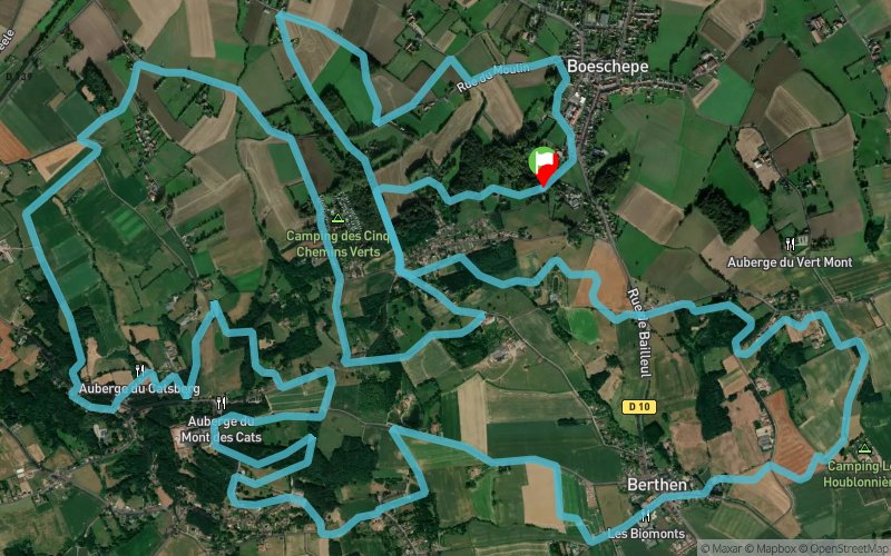


21.8 km
880 m
880 m
 Boeschepe (59)
 Points of Interest table
| Accum. | Intermediary | |||||||
|---|---|---|---|---|---|---|---|---|
| POI | Description | Alt. | Dist. | D+ | D- | Dist. | D+ | D- |
Trace n°66410
Ascent threshold : 3 m Distance threshold : 30 m Smoothing : No Origin of altitudes : MNT Aster GDEM
Ascent threshold : 3 m Distance threshold : 30 m Smoothing : No Origin of altitudes : MNT Aster GDEM
Loop
Dominant terrain : Path
Max alti. : 165 m
Avg alti. : 94 m
Min alti. : 44 m
Longest ascent : 160 m
Longest descent : 110 m
Route completed by the author : No
Dominant terrain : Path
Max alti. : 165 m
Avg alti. : 94 m
Min alti. : 44 m
Longest ascent : 160 m
Longest descent : 110 m
Route completed by the author : No
Elevation profile
More tools
Create a new roadbook page
Map and track on your website
Warning ! When you insert a Trace de Trail map on your website, you agree not to hide any element of the module (links to Trail Trail or Trail Connect banner)
Add a realisation
Validate
Add a realisation to share your chrono and describe the conditions that you encountered during you trail running !
Add a comment
Validate
Antoine Le Rouge
03/06/19, 15:44:23
Juin2019 - Malheureusement, il y a plusieurs chemins pratiqués par la trace qui ne sont pas accessibles (terrains privés et clôturés, champs fermés avec végétation dense) notamment sur le secteur 16km -19km ou il faut rejoindre la route.
03/06/19, 15:44:23
Juin2019 - Malheureusement, il y a plusieurs chemins pratiqués par la trace qui ne sont pas accessibles (terrains privés et clôturés, champs fermés avec végétation dense) notamment sur le secteur 16km -19km ou il faut rejoindre la route.
Show the infos
Add a track


